La Grandeza geodata
La Grandeza (Veracruz) is a populated place; located in Mexico in America/Mexico_City (GMT-6) time zone. With population of 857 people, there are 10207 cities with bigger population in this country. Compared to other cities in Mexico, 68.2% of cities are located further ↓South; 70.7% of cities are located further ←West and 77.8% of cities have higher elevation than La Grandeza. Note1


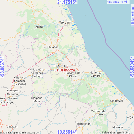
La Grandeza GPS coordinates[2]
20° 31' 5.016" North, 97° 23' 0.996" West
| Map corner | latitude | longitude |
|---|---|---|
| Upper-left | 21.17515°, | -98.08674° |
| Center: | 20.51806°, | -97.38361° |
| Lower-right: | 19.85814°, | -96.68049° |
| Map W x H: | 146.4×146.4 km | = 91×91mi |
| max Lat: | 32.7° ⇑31.8% North |
| La Grandeza: | 20.51806° |
| min Lat: | ⇓68.2% South 14.53588° |
| min Long | La Grandeza | max Long |
| -117.105° | -97.38361° | -86.73105° |
| W 70.7%⇐ | ⇒29.3% E |
Elevation
Elevation of La Grandeza is 134 m = 440 ft, and this is 1119.7 m = 3674 ft below average elevation for this country.
| Max E: |
3497 m = 11473 ft | 77.8% |
| Avg. | 1253.7 m = 4113 ft | |
| La Grandeza | 134 m = 440 ft | |
Min E: |
-1 m = -3 ft | 22.2% |
See also: Mexico elevation on elevation.city.
Geographical zone
La Grandeza is located in North Torrid zone (between Equator and Tropic of Cancer). Distance of this Northern Tropic circle is 324.5 km =201.6 mi to North.| Distance of | km | miles | from La Grandeza |
|---|---|---|---|
| North Pole | 7725.7 | 4800.5 | to North |
| Arctic Circle | 5119.8 | 3181.3 | to North |
| Tropic Cancer | 324.5 | 201.6 | to North |
| Equator | 2281.4 | 1417.6 | to South |


Nearby cities:
15 places around La Grandeza: (largest is in red/bold)
• Arroyo del Maíz Uno
3.9 km =2.4 mi,  302°
302°
• Coatzintla
9.5 km =5.9 mi,  248°
248°
• Colonia las Arboledas
9.2 km =5.7 mi,  332°
332°
• Donato Márquez Azuara
2.2 km =1.4 mi,  68°
68°
• El Cabellal
3.9 km =2.4 mi,  36°
36°
• El Mollejon
3.9 km =2.4 mi,  313°
313°
• Escolín de Olarte
4.7 km =2.9 mi,  242°
242°
• Fraccionamiento la Florida
8.9 km =5.5 mi, 328°
• Plan de los Mangos
6.8 km =4.2 mi,  46°
46°
• Poza Rica de Hidalgo
8.1 km =5 mi,  281°
281°
• Reforma Escolín
3.4 km =2.1 mi,  184°
184°
• Residencial Tajín
9.5 km =5.9 mi,  338°
338°
• Santa Águeda
7.9 km =4.9 mi,  63°
63°
• Vicente Herrera
7.4 km =4.6 mi,  28°
28°
• Villa de las Flores
8.3 km =5.2 mi,  321°
321°
Sources, notices
• [Note1] Compared only with cities in Mexico existing in our database
• [Src1] Map data: © OpenStreetMap contributors (CC-BY-SA)
• [Src2] Other city data from geonames.org with taken over terms of usage.
• [Src3] Geographical zone / Annual Mean Temperature by Robert A. Rohde @ Wikipedia
