Melchor Ocampo geodata
Melchor Ocampo (Veracruz) is a populated place; located in Mexico in America/Mexico_City (GMT-6) time zone. With population of 1,126 people, there are 7698 cities with bigger population in this country. Compared to other cities in Mexico, 64.5% of cities are located further ↓South; 69.2% of cities are located further ←West and 77.7% of cities have higher elevation than Melchor Ocampo. Note1


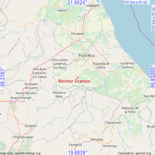
Melchor Ocampo GPS coordinates[2]
20° 20' 40.416" North, 97° 32' 6.612" West
| Map corner | latitude | longitude |
|---|---|---|
| Upper-left | 21.0024°, | -98.2383° |
| Center: | 20.34456°, | -97.53517° |
| Lower-right: | 19.6839°, | -96.83205° |
| Map W x H: | 146.6×146.6 km | = 91.1×91.1mi |
| max Lat: | 32.7° ⇑35.5% North |
| Melchor Ocampo: | 20.34456° |
| min Lat: | ⇓64.5% South 14.53588° |
| min Long | Melchor Ocampo | max Long |
| -117.105° | -97.53517° | -86.73105° |
| W 69.2%⇐ | ⇒30.8% E |
Elevation
Elevation of Melchor Ocampo is 138 m = 453 ft, and this is 1115.7 m = 3660 ft below average elevation for this country.
| Max E: |
3497 m = 11473 ft | 77.7% |
| Avg. | 1253.7 m = 4113 ft | |
| Melchor Ocampo | 138 m = 453 ft | |
Min E: |
-1 m = -3 ft | 22.3% |
See also: Mexico elevation on elevation.city.
Geographical zone
Melchor Ocampo is located in North Torrid zone (between Equator and Tropic of Cancer). Distance of this Northern Tropic circle is 343.8 km =213.6 mi to North.| Distance of | km | miles | from Melchor Ocampo |
|---|---|---|---|
| North Pole | 7745 | 4812.5 | to North |
| Arctic Circle | 5139.1 | 3193.3 | to North |
| Tropic Cancer | 343.8 | 213.6 | to North |
| Equator | 2262.1 | 1405.6 | to South |


Nearby cities:
15 places around Melchor Ocampo: (largest is in red/bold)
• Buenavista
6.3 km =3.9 mi,  148°
148°
• El Pacífico
8.7 km =5.4 mi,  205°
205°
• Entabladero
7.9 km =4.9 mi,  192°
192°
• Francisco Sarabia
3.1 km =1.9 mi,  53°
53°
• Guadalupe Victoria
4.8 km =3 mi,  323°
323°
• La Colonia Guadalupe
9.1 km =5.7 mi,  269°
269°
• La Noria
8.2 km =5.1 mi,  199°
199°
• Oriente Medio Día
9.4 km =5.8 mi, 145°
• Oriente Meridiano
8.1 km =5 mi,  141°
141°
• Poza Larga Zapotal
6.5 km =4 mi,  108°
108°
• Sabanita
9.1 km =5.7 mi, 192°
• San Fernando Coapechapa
9.3 km =5.8 mi,  286°
286°
• San Leoncio Jamaya
6 km =3.7 mi,  233°
233°
• San Marcos
6.3 km =3.9 mi, 271°
• Santa Catarina y Ciruelo
7.6 km =4.7 mi,  124°
124°
Sources, notices
• [Note1] Compared only with cities in Mexico existing in our database
• [Src1] Map data: © OpenStreetMap contributors (CC-BY-SA)
• [Src2] Other city data from geonames.org with taken over terms of usage.
• [Src3] Geographical zone / Annual Mean Temperature by Robert A. Rohde @ Wikipedia
