Poza Larga Zapotal geodata
Poza Larga Zapotal (Veracruz) is a populated place; located in Mexico in America/Mexico_City (GMT-6) time zone. With population of 961 people, there are 9056 cities with bigger population in this country. Compared to other cities in Mexico, 64% of cities are located further ↓South; 69.8% of cities are located further ←West and 78.1% of cities have higher elevation than Poza Larga Zapotal. Note1


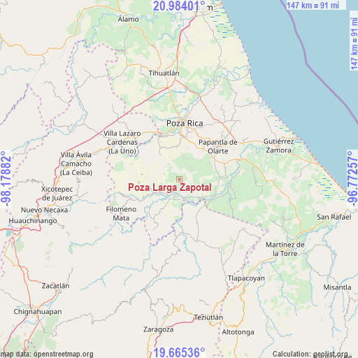
Poza Larga Zapotal GPS coordinates[2]
20° 19' 33.924" North, 97° 28' 32.484" West
| Map corner | latitude | longitude |
|---|---|---|
| Upper-left | 20.98401°, | -98.17882° |
| Center: | 20.32609°, | -97.47569° |
| Lower-right: | 19.66536°, | -96.77257° |
| Map W x H: | 146.6×146.6 km | = 91.1×91.1mi |
| max Lat: | 32.7° ⇑36% North |
| Poza Larga Zapotal: | 20.32609° |
| min Lat: | ⇓64% South 14.53588° |
| min Long | Poza Larga Zapo | max Long |
| -117.105° | -97.47569° | -86.73105° |
| W 69.8%⇐ | ⇒30.2% E |
Elevation
Elevation of Poza Larga Zapotal is 130 m = 427 ft, and this is 1123.7 m = 3687 ft below average elevation for this country.
| Max E: |
3497 m = 11473 ft | 78.1% |
| Avg. | 1253.7 m = 4113 ft | |
| Poza Larga Zapotal | 130 m = 427 ft | |
Min E: |
-1 m = -3 ft | 21.9% |
See also: Mexico elevation on elevation.city.
Geographical zone
Poza Larga Zapotal is located in North Torrid zone (between Equator and Tropic of Cancer). Distance of this Northern Tropic circle is 345.9 km =214.9 mi to North.| Distance of | km | miles | from Poza Larga Zapotal |
|---|---|---|---|
| North Pole | 7747 | 4813.8 | to North |
| Arctic Circle | 5141.1 | 3194.5 | to North |
| Tropic Cancer | 345.9 | 214.9 | to North |
| Equator | 2260 | 1404.3 | to South |


Nearby cities:
15 places around Poza Larga Zapotal: (largest is in red/bold)
• Buenavista
4.4 km =2.7 mi,  221°
221°
• Comalteco
8.6 km =5.3 mi,  177°
177°
• El Arenal
9.2 km =5.7 mi,  206°
206°
• Entabladero
9.7 km =6 mi,  234°
234°
• Francisco Sarabia
5.4 km =3.4 mi,  316°
316°
• José María Morelos
6.2 km =3.9 mi,  94°
94°
• La Noria
10.5 km =6.5 mi,  237°
237°
• Melchor Ocampo
6.5 km =4 mi,  288°
288°
• Ojite de Matamoros
8.5 km =5.3 mi,  193°
193°
• Oriente Medio Día
5.7 km =3.5 mi, 188°
• Oriente Meridiano
4.4 km =2.7 mi, 194°
• Plan de Hidalgo
9 km =5.6 mi,  23°
23°
• Plan del Palmar
9.3 km =5.8 mi,  13°
13°
• Santa Catarina y Ciruelo
2.3 km =1.4 mi, 178°
• Vista Hermosa de Madero
6.8 km =4.2 mi,  42°
42°
Sources, notices
• [Note1] Compared only with cities in Mexico existing in our database
• [Src1] Map data: © OpenStreetMap contributors (CC-BY-SA)
• [Src2] Other city data from geonames.org with taken over terms of usage.
• [Src3] Geographical zone / Annual Mean Temperature by Robert A. Rohde @ Wikipedia
