Las Limas geodata
Las Limas (Veracruz) is a populated place; located in Mexico in America/Mexico_City (GMT-6) time zone. With population of 906 people, there are 9634 cities with bigger population in this country. Compared to other cities in Mexico, 72.9% of cities are located further ↑North; 78.1% of cities are located further ←West and 78.6% of cities have higher elevation than Las Limas. Note1


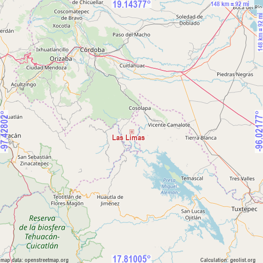
Las Limas GPS coordinates[2]
18° 28' 41.556" North, 96° 43' 29.604" West
| Map corner | latitude | longitude |
|---|---|---|
| Upper-left | 19.14377°, | -97.42802° |
| Center: | 18.47821°, | -96.72489° |
| Lower-right: | 17.81005°, | -96.02177° |
| Map W x H: | 148.3×148.3 km | = 92.1×92.1mi |
| max Lat: | 32.7° ⇑72.9% North |
| Las Limas: | 18.47821° |
| min Lat: | ⇓27.1% South 14.53588° |
| min Long | Las Limas | max Long |
| -117.105° | -96.72489° | -86.73105° |
| W 78.1%⇐ | ⇒21.9% E |
Elevation
Elevation of Las Limas is 118 m = 387 ft, and this is 1135.7 m = 3726 ft below average elevation for this country.
| Max E: |
3497 m = 11473 ft | 78.6% |
| Avg. | 1253.7 m = 4113 ft | |
| Las Limas | 118 m = 387 ft | |
Min E: |
-1 m = -3 ft | 21.4% |
See also: Mexico elevation on elevation.city.
Geographical zone
Las Limas is located in North Torrid zone (between Equator and Tropic of Cancer). Distance of this Northern Tropic circle is 551.3 km =342.6 mi to North.| Distance of | km | miles | from Las Limas |
|---|---|---|---|
| North Pole | 7952.5 | 4941.5 | to North |
| Arctic Circle | 5346.6 | 3322.2 | to North |
| Tropic Cancer | 551.3 | 342.6 | to North |
| Equator | 2054.6 | 1276.7 | to South |


Nearby cities:
15 places around Las Limas: (largest is in red/bold)
• Almilinga
9.1 km =5.7 mi,  310°
310°
• Atlizacuapan
4.2 km =2.6 mi,  251°
251°
• Caxapa
7.4 km =4.6 mi,  224°
224°
• El Suspiro
5.8 km =3.6 mi,  256°
256°
• Ixtacapa el Chico
2.3 km =1.4 mi, 305°
• La Junta
7.3 km =4.5 mi,  78°
78°
• Laguna Chica (Pueblo Nuevo)
7.3 km =4.5 mi,  353°
353°
• Las Josefinas
3.7 km =2.3 mi,  64°
64°
• Limonestitla
11.3 km =7 mi,  285°
285°
• Palmar Grande
7 km =4.3 mi, 305°
• Rancho Nuevo
9.1 km =5.7 mi,  323°
323°
• Raya Caracol
11.2 km =7 mi,  163°
163°
• San Agustín del Palmar
4.3 km =2.7 mi,  5°
5°
• San Martín Mazateopan
10 km =6.2 mi, 253°
• Tentziantla (San Marcos)
10.1 km =6.3 mi, 264°
Sources, notices
• [Note1] Compared only with cities in Mexico existing in our database
• [Src1] Map data: © OpenStreetMap contributors (CC-BY-SA)
• [Src2] Other city data from geonames.org with taken over terms of usage.
• [Src3] Geographical zone / Annual Mean Temperature by Robert A. Rohde @ Wikipedia
