Caxapa geodata
Caxapa (Veracruz) is a populated place; located in Mexico in America/Mexico_City (GMT-6) time zone. With population of 1,903 people, there are 4568 cities with bigger population in this country. Compared to other cities in Mexico, 73.4% of cities are located further ↑North; 77.6% of cities are located further ←West and 79.3% of cities have higher elevation than Caxapa. Note1


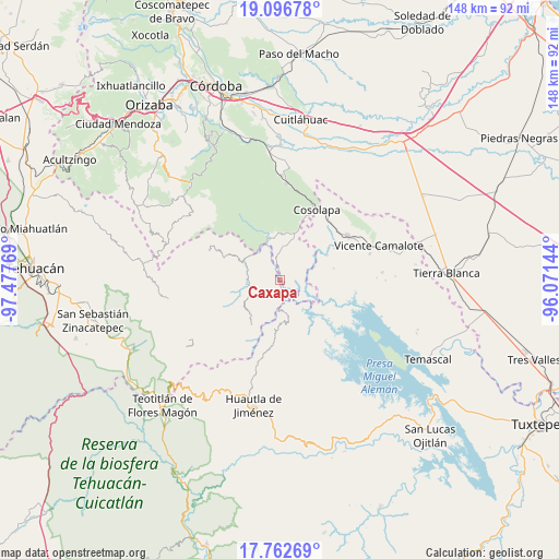
Caxapa GPS coordinates[2]
18° 25' 51.708" North, 96° 46' 28.416" West
| Map corner | latitude | longitude |
|---|---|---|
| Upper-left | 19.09678°, | -97.47769° |
| Center: | 18.43103°, | -96.77456° |
| Lower-right: | 17.76269°, | -96.07144° |
| Map W x H: | 148.3×148.3 km | = 92.1×92.1mi |
| max Lat: | 32.7° ⇑73.4% North |
| Caxapa: | 18.43103° |
| min Lat: | ⇓26.6% South 14.53588° |
| min Long | Caxapa | max Long |
| -117.105° | -96.77456° | -86.73105° |
| W 77.6%⇐ | ⇒22.4% E |
Elevation
Elevation of Caxapa is 105 m = 344 ft, and this is 1148.7 m = 3769 ft below average elevation for this country.
| Max E: |
3497 m = 11473 ft | 79.3% |
| Avg. | 1253.7 m = 4113 ft | |
| Caxapa | 105 m = 344 ft | |
Min E: |
-1 m = -3 ft | 20.7% |
See also: Mexico elevation on elevation.city.
Geographical zone
Caxapa is located in North Torrid zone (between Equator and Tropic of Cancer). Distance of this Northern Tropic circle is 556.6 km =345.9 mi to North.| Distance of | km | miles | from Caxapa |
|---|---|---|---|
| North Pole | 7957.7 | 4944.7 | to North |
| Arctic Circle | 5351.8 | 3325.5 | to North |
| Tropic Cancer | 556.6 | 345.9 | to North |
| Equator | 2049.3 | 1273.4 | to South |


Nearby cities:
15 places around Caxapa: (largest is in red/bold)
• Almilinga
11.3 km =7 mi,  351°
351°
• Atlizacuapan
4.1 km =2.5 mi,  18°
18°
• Coyolapa
11.7 km =7.3 mi,  261°
261°
• El Suspiro
3.9 km =2.4 mi, 354°
• Ixtacapa el Chico
7.4 km =4.6 mi,  27°
27°
• Las Josefinas
11 km =6.8 mi,  51°
51°
• Las Limas
7.4 km =4.6 mi,  44°
44°
• Limonestitla
10 km =6.2 mi,  325°
325°
• Palmar Grande
9.4 km =5.8 mi,  357°
357°
• Raya Caracol
10.1 km =6.3 mi,  122°
122°
• San Agustín del Palmar
11.1 km =6.9 mi, 30°
• San Martín Mazateopan
5 km =3.1 mi,  298°
298°
• Tentziantla (San Marcos)
6.4 km =4 mi,  310°
310°
• Tepetlampa
11.4 km =7.1 mi, 330°
• Tlacotepec
8.6 km =5.3 mi,  249°
249°
Sources, notices
• [Note1] Compared only with cities in Mexico existing in our database
• [Src1] Map data: © OpenStreetMap contributors (CC-BY-SA)
• [Src2] Other city data from geonames.org with taken over terms of usage.
• [Src3] Geographical zone / Annual Mean Temperature by Robert A. Rohde @ Wikipedia
