Palmar Grande geodata
Palmar Grande (Veracruz) is a populated place; located in Mexico in America/Mexico_City (GMT-6) time zone. With population of 1,120 people, there are 7751 cities with bigger population in this country. Compared to other cities in Mexico, 72.4% of cities are located further ↑North; 77.5% of cities are located further ←West and 77.9% of cities have higher elevation than Palmar Grande. Note1


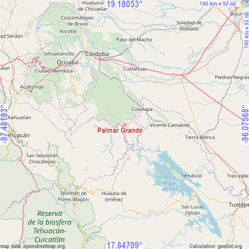
Palmar Grande GPS coordinates[2]
18° 30' 54.396" North, 96° 46' 43.68" West
| Map corner | latitude | longitude |
|---|---|---|
| Upper-left | 19.18053°, | -97.48193° |
| Center: | 18.51511°, | -96.7788° |
| Lower-right: | 17.84709°, | -96.07568° |
| Map W x H: | 148.3×148.3 km | = 92.1×92.1mi |
| max Lat: | 32.7° ⇑72.4% North |
| Palmar Grande: | 18.51511° |
| min Lat: | ⇓27.6% South 14.53588° |
| min Long | Palmar Grande | max Long |
| -117.105° | -96.7788° | -86.73105° |
| W 77.5%⇐ | ⇒22.5% E |
Elevation
Elevation of Palmar Grande is 133 m = 436 ft, and this is 1120.7 m = 3677 ft below average elevation for this country.
| Max E: |
3497 m = 11473 ft | 77.9% |
| Avg. | 1253.7 m = 4113 ft | |
| Palmar Grande | 133 m = 436 ft | |
Min E: |
-1 m = -3 ft | 22.1% |
See also: Mexico elevation on elevation.city.
Geographical zone
Palmar Grande is located in North Torrid zone (between Equator and Tropic of Cancer). Distance of this Northern Tropic circle is 547.2 km =340 mi to North.| Distance of | km | miles | from Palmar Grande |
|---|---|---|---|
| North Pole | 7948.4 | 4938.9 | to North |
| Arctic Circle | 5342.5 | 3319.7 | to North |
| Tropic Cancer | 547.2 | 340 | to North |
| Equator | 2058.7 | 1279.2 | to South |


Nearby cities:
15 places around Palmar Grande: (largest is in red/bold)
• Almilinga
2.2 km =1.4 mi,  325°
325°
• Atlizacuapan
5.7 km =3.5 mi,  162°
162°
• Caxapa
9.4 km =5.8 mi,  177°
177°
• El Suspiro
5.5 km =3.4 mi, 179°
• Ixtacapa el Chico
4.7 km =2.9 mi,  126°
126°
• Laguna Chica (Pueblo Nuevo)
5.7 km =3.5 mi,  57°
57°
• Las Josefinas
9.4 km =5.8 mi,  105°
105°
• Las Limas
7 km =4.3 mi, 125°
• Limonestitla
5.3 km =3.3 mi,  258°
258°
• Rancho Nuevo
3.2 km =2 mi,  4°
4°
• San Agustín del Palmar
6.1 km =3.8 mi,  88°
88°
• San Martín Mazateopan
8 km =5 mi,  209°
209°
• Tentziantla (San Marcos)
6.8 km =4.2 mi,  220°
220°
• Tepetlampa
5.3 km =3.3 mi,  276°
276°
• Tilica
6.2 km =3.9 mi,  308°
308°
Sources, notices
• [Note1] Compared only with cities in Mexico existing in our database
• [Src1] Map data: © OpenStreetMap contributors (CC-BY-SA)
• [Src2] Other city data from geonames.org with taken over terms of usage.
• [Src3] Geographical zone / Annual Mean Temperature by Robert A. Rohde @ Wikipedia
