Nuevo San Martín geodata
Nuevo San Martín (Oaxaca) is a populated place; located in Mexico in America/Mexico_City (GMT-6) time zone. With population of 1,195 people, there are 7266 cities with bigger population in this country. Compared to other cities in Mexico, 82.4% of cities are located further ↑North; 83.1% of cities are located further ←West and 81.6% of cities have higher elevation than Nuevo San Martín. Note1


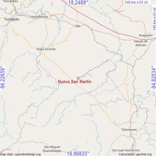
Nuevo San Martín GPS coordinates[2]
17° 34' 47.532" North, 95° 31' 24.456" West
| Map corner | latitude | longitude |
|---|---|---|
| Upper-left | 18.2489°, | -96.22659° |
| Center: | 17.57987°, | -95.52346° |
| Lower-right: | 16.90835°, | -94.82034° |
| Map W x H: | 149.1×149.1 km | = 92.6×92.6mi |
| max Lat: | 32.7° ⇑82.4% North |
| Nuevo San Martín: | 17.57987° |
| min Lat: | ⇓17.6% South 14.53588° |
| min Long | Nuevo San Mart� | max Long |
| -117.105° | -95.52346° | -86.73105° |
| W 83.1%⇐ | ⇒16.9% E |
Elevation
Elevation of Nuevo San Martín is 74 m = 243 ft, and this is 1179.7 m = 3870 ft below average elevation for this country.
| Max E: |
3497 m = 11473 ft | 81.6% |
| Avg. | 1253.7 m = 4113 ft | |
| Nuevo San Martín | 74 m = 243 ft | |
Min E: |
-1 m = -3 ft | 18.4% |
See also: Mexico elevation on elevation.city.
Geographical zone
Nuevo San Martín is located in North Torrid zone (between Equator and Tropic of Cancer). Distance of this Northern Tropic circle is 651.2 km =404.6 mi to North.| Distance of | km | miles | from Nuevo San Martín |
|---|---|---|---|
| North Pole | 8052.4 | 5003.5 | to North |
| Arctic Circle | 5446.5 | 3384.3 | to North |
| Tropic Cancer | 651.2 | 404.6 | to North |
| Equator | 1954.7 | 1214.6 | to South |


Nearby cities:
15 places around Nuevo San Martín: (largest is in red/bold)
• Abasolo del Valle
22.7 km =14.1 mi,  354°
354°
• Arroyo Carrizal
17.2 km =10.7 mi,  148°
148°
• Arroyo Colorado (Cruz Verde)
18.6 km =11.6 mi,  255°
255°
• Boca del Monte
22.4 km =13.9 mi,  279°
279°
• Dolores Hidalgo
11.2 km =7 mi,  158°
158°
• Francisco Villa
13.8 km =8.6 mi, 148°
• La Trinidad
15.8 km =9.8 mi,  189°
189°
• María Lombardo de Caso
17.7 km =11 mi, 145°
• Nuevo Cerro Mojarra
25.4 km =15.8 mi,  125°
125°
• Nuevo Ixcatlán
11.3 km =7 mi,  52°
52°
• Paso del Águila
12.8 km =8 mi,  252°
252°
• San Felipe Cihualtepec
20.1 km =12.5 mi,  124°
124°
• Santa Teresa
20.4 km =12.7 mi,  309°
309°
• Tatahuicapá
12.9 km =8 mi, 255°
• Xochiapa
24.3 km =15.1 mi,  292°
292°
Sources, notices
• [Note1] Compared only with cities in Mexico existing in our database
• [Src1] Map data: © OpenStreetMap contributors (CC-BY-SA)
• [Src2] Other city data from geonames.org with taken over terms of usage.
• [Src3] Geographical zone / Annual Mean Temperature by Robert A. Rohde @ Wikipedia
