Paso del Águila geodata
Paso del Águila (Oaxaca) is a populated place; located in Mexico in America/Mexico_City (GMT-6) time zone. With population of 630 people, there are 13737 cities with bigger population in this country. Compared to other cities in Mexico, 82.7% of cities are located further ↑North; 83% of cities are located further ←West and 80.3% of cities have higher elevation than Paso del Águila. Note1


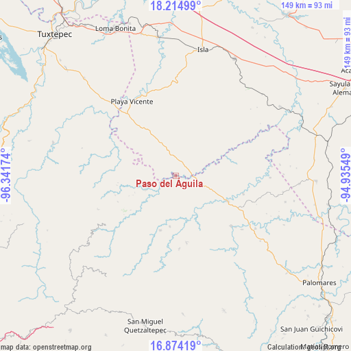
Paso del Águila GPS coordinates[2]
17° 32' 44.988" North, 95° 38' 18.996" West
| Map corner | latitude | longitude |
|---|---|---|
| Upper-left | 18.21499°, | -96.34174° |
| Center: | 17.54583°, | -95.63861° |
| Lower-right: | 16.87419°, | -94.93549° |
| Map W x H: | 149.1×149.1 km | = 92.6×92.6mi |
| max Lat: | 32.7° ⇑82.7% North |
| Paso del Águila: | 17.54583° |
| min Lat: | ⇓17.3% South 14.53588° |
| min Long | Paso del Águil | max Long |
| -117.105° | -95.63861° | -86.73105° |
| W 83%⇐ | ⇒17% E |
Elevation
Elevation of Paso del Águila is 90 m = 295 ft, and this is 1163.7 m = 3818 ft below average elevation for this country.
| Max E: |
3497 m = 11473 ft | 80.3% |
| Avg. | 1253.7 m = 4113 ft | |
| Paso del Águila | 90 m = 295 ft | |
Min E: |
-1 m = -3 ft | 19.7% |
See also: Mexico elevation on elevation.city.
Geographical zone
Paso del Águila is located in North Torrid zone (between Equator and Tropic of Cancer). Distance of this Northern Tropic circle is 655 km =407 mi to North.| Distance of | km | miles | from Paso del Águila |
|---|---|---|---|
| North Pole | 8056.1 | 5005.8 | to North |
| Arctic Circle | 5450.3 | 3386.7 | to North |
| Tropic Cancer | 655 | 407 | to North |
| Equator | 1950.9 | 1212.2 | to South |


Nearby cities:
15 places around Paso del Águila: (largest is in red/bold)
• Arroyo Colorado (Cruz Verde)
5.8 km =3.6 mi,  263°
263°
• Arroyo de Piedra
22.4 km =13.9 mi,  277°
277°
• Boca del Monte
12.4 km =7.7 mi,  307°
307°
• Dolores Hidalgo
17.6 km =10.9 mi,  112°
112°
• Francisco Villa
21 km =13 mi, 112°
• La Esperanza
13.7 km =8.5 mi, 258°
• La Trinidad
15.2 km =9.4 mi,  141°
141°
• Nuevo San Martín
12.8 km =8 mi,  72°
72°
• San Juan Jaltepec
21.6 km =13.4 mi,  186°
186°
• San Juan del Río
14.2 km =8.8 mi,  245°
245°
• San Lorenzo
15.3 km =9.5 mi,  285°
285°
• Santa Teresa
17 km =10.6 mi,  347°
347°
• Santiago Jalahui
17.3 km =10.7 mi,  234°
234°
• Tatahuicapá
0.6 km =0.4 mi,  337°
337°
• Xochiapa
16.6 km =10.3 mi,  322°
322°
Sources, notices
• [Note1] Compared only with cities in Mexico existing in our database
• [Src1] Map data: © OpenStreetMap contributors (CC-BY-SA)
• [Src2] Other city data from geonames.org with taken over terms of usage.
• [Src3] Geographical zone / Annual Mean Temperature by Robert A. Rohde @ Wikipedia
