Tatahuicapá geodata
Tatahuicapá (Oaxaca) is a populated place; located in Mexico in America/Mexico_City (GMT-6) time zone. With population of 1,436 people, there are 6013 cities with bigger population in this country. Compared to other cities in Mexico, 82.6% of cities are located further ↑North; 83% of cities are located further ←West and 80% of cities have higher elevation than Tatahuicapá. Note1


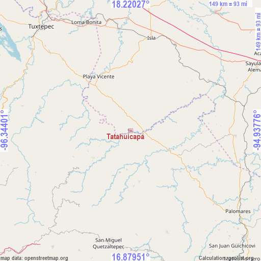
Tatahuicapá GPS coordinates[2]
17° 33' 4.068" North, 95° 38' 27.168" West
| Map corner | latitude | longitude |
|---|---|---|
| Upper-left | 18.22027°, | -96.34401° |
| Center: | 17.55113°, | -95.64088° |
| Lower-right: | 16.87951°, | -94.93776° |
| Map W x H: | 149.1×149.1 km | = 92.6×92.6mi |
| max Lat: | 32.7° ⇑82.6% North |
| Tatahuicapá: | 17.55113° |
| min Lat: | ⇓17.4% South 14.53588° |
| min Long | Tatahuicapá | max Long |
| -117.105° | -95.64088° | -86.73105° |
| W 83%⇐ | ⇒17% E |
Elevation
Elevation of Tatahuicapá is 95 m = 312 ft, and this is 1158.7 m = 3802 ft below average elevation for this country.
| Max E: |
3497 m = 11473 ft | 80% |
| Avg. | 1253.7 m = 4113 ft | |
| Tatahuicapá | 95 m = 312 ft | |
Min E: |
-1 m = -3 ft | 20% |
See also: Mexico elevation on elevation.city.
Geographical zone
Tatahuicapá is located in North Torrid zone (between Equator and Tropic of Cancer). Distance of this Northern Tropic circle is 654.4 km =406.6 mi to North.| Distance of | km | miles | from Tatahuicapá |
|---|---|---|---|
| North Pole | 8055.6 | 5005.5 | to North |
| Arctic Circle | 5449.7 | 3386.3 | to North |
| Tropic Cancer | 654.4 | 406.6 | to North |
| Equator | 1951.5 | 1212.6 | to South |


Nearby cities:
15 places around Tatahuicapá: (largest is in red/bold)
• Arroyo Colorado (Cruz Verde)
5.7 km =3.5 mi,  256°
256°
• Arroyo de Piedra
22.1 km =13.7 mi,  276°
276°
• Boca del Monte
11.9 km =7.4 mi,  306°
306°
• Dolores Hidalgo
18 km =11.2 mi,  113°
113°
• Francisco Villa
21.5 km =13.4 mi, 113°
• La Esperanza
13.6 km =8.5 mi, 256°
• La Trinidad
15.8 km =9.8 mi,  141°
141°
• Nuevo San Martín
12.9 km =8 mi,  75°
75°
• Paso del Águila
0.6 km =0.4 mi,  157°
157°
• San Juan del Río
14.2 km =8.8 mi,  242°
242°
• San Lorenzo
14.9 km =9.3 mi, 283°
• Santa Teresa
16.4 km =10.2 mi,  348°
348°
• Santiago Jalahui
17.5 km =10.9 mi,  232°
232°
• Tomatillo
21.9 km =13.6 mi,  319°
319°
• Xochiapa
16 km =9.9 mi, 321°
Sources, notices
• [Note1] Compared only with cities in Mexico existing in our database
• [Src1] Map data: © OpenStreetMap contributors (CC-BY-SA)
• [Src2] Other city data from geonames.org with taken over terms of usage.
• [Src3] Geographical zone / Annual Mean Temperature by Robert A. Rohde @ Wikipedia
