Abasolo del Valle geodata
Abasolo del Valle (Veracruz) is a populated place; located in Mexico in America/Mexico_City (GMT-6) time zone. With population of 3,691 people, there are 2486 cities with bigger population in this country. Compared to other cities in Mexico, 80.7% of cities are located further ↑North; 83.1% of cities are located further ←West and 76.3% of cities have higher elevation than Abasolo del Valle. Note1


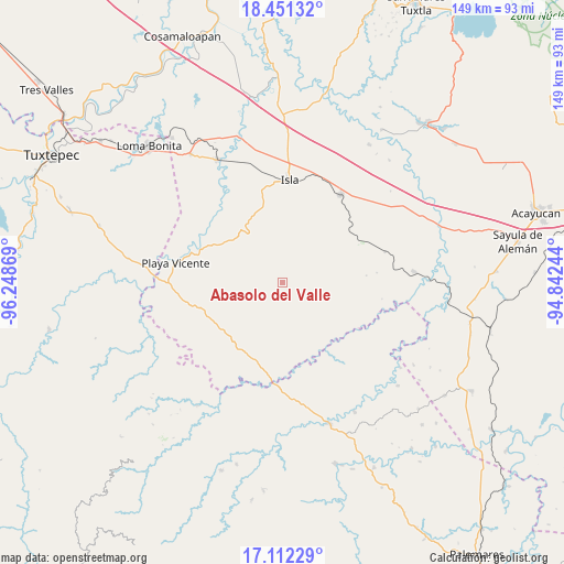
Abasolo del Valle GPS coordinates[2]
17° 46' 59.016" North, 95° 32' 44.016" West
| Map corner | latitude | longitude |
|---|---|---|
| Upper-left | 18.45132°, | -96.24869° |
| Center: | 17.78306°, | -95.54556° |
| Lower-right: | 17.11229°, | -94.84244° |
| Map W x H: | 148.9×148.9 km | = 92.5×92.5mi |
| max Lat: | 32.7° ⇑80.7% North |
| Abasolo del Valle: | 17.78306° |
| min Lat: | ⇓19.3% South 14.53588° |
| min Long | Abasolo del Val | max Long |
| -117.105° | -95.54556° | -86.73105° |
| W 83.1%⇐ | ⇒16.9% E |
Elevation
Elevation of Abasolo del Valle is 175 m = 574 ft, and this is 1078.7 m = 3539 ft below average elevation for this country.
| Max E: |
3497 m = 11473 ft | 76.3% |
| Avg. | 1253.7 m = 4113 ft | |
| Abasolo del Valle | 175 m = 574 ft | |
Min E: |
-1 m = -3 ft | 23.7% |
See also: Mexico elevation on elevation.city.
Geographical zone
Abasolo del Valle is located in North Torrid zone (between Equator and Tropic of Cancer). Distance of this Northern Tropic circle is 628.6 km =390.6 mi to North.| Distance of | km | miles | from Abasolo del Valle |
|---|---|---|---|
| North Pole | 8029.8 | 4989.5 | to North |
| Arctic Circle | 5423.9 | 3370.3 | to North |
| Tropic Cancer | 628.6 | 390.6 | to North |
| Equator | 1977.3 | 1228.6 | to South |


Nearby cities:
15 places around Abasolo del Valle: (largest is in red/bold)
• Arenal Santa Ana
23.7 km =14.7 mi,  271°
271°
• Boca del Monte
27.2 km =16.9 mi,  226°
226°
• El Marcial
26.4 km =16.4 mi,  326°
326°
• El Nigromante
22.5 km =14 mi,  264°
264°
• Isla
27.3 km =17 mi,  3°
3°
• La Victoria
25 km =15.5 mi,  296°
296°
• Lealtad de Muñoz
19.2 km =11.9 mi, 302°
• Loma Alta
23.7 km =14.7 mi,  336°
336°
• Los Tigres (San Marcos)
24 km =14.9 mi,  60°
60°
• Nuevo Ixcatlán
19.4 km =12.1 mi,  144°
144°
• Nuevo San Martín
22.7 km =14.1 mi,  174°
174°
• Santa Teresa
16.6 km =10.3 mi, 234°
• Tomatillo
26 km =16.2 mi,  249°
249°
• Totoloche
14 km =8.7 mi,  6°
6°
• Xochiapa
24.1 km =15 mi,  236°
236°
Sources, notices
• [Note1] Compared only with cities in Mexico existing in our database
• [Src1] Map data: © OpenStreetMap contributors (CC-BY-SA)
• [Src2] Other city data from geonames.org with taken over terms of usage.
• [Src3] Geographical zone / Annual Mean Temperature by Robert A. Rohde @ Wikipedia
