Campo Nuevo geodata
Campo Nuevo (Veracruz) is a populated place; located in Mexico in America/Mexico_City (GMT-6) time zone. With population of 896 people, there are 9729 cities with bigger population in this country. Compared to other cities in Mexico, 81.3% of cities are located further ↑North; 84.4% of cities are located further ←West and 80.1% of cities have higher elevation than Campo Nuevo. Note1


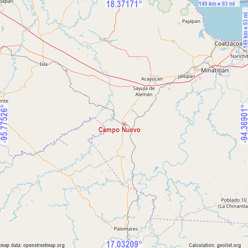
Campo Nuevo GPS coordinates[2]
17° 42' 11.34" North, 95° 4' 19.668" West
| Map corner | latitude | longitude |
|---|---|---|
| Upper-left | 18.37171°, | -95.77526° |
| Center: | 17.70315°, | -95.07213° |
| Lower-right: | 17.03209°, | -94.36901° |
| Map W x H: | 149×149 km | = 92.6×92.6mi |
| max Lat: | 32.7° ⇑81.3% North |
| Campo Nuevo: | 17.70315° |
| min Lat: | ⇓18.7% South 14.53588° |
| min Long | Campo Nuevo | max Long |
| -117.105° | -95.07213° | -86.73105° |
| W 84.4%⇐ | ⇒15.6% E |
Elevation
Elevation of Campo Nuevo is 93 m = 305 ft, and this is 1160.7 m = 3808 ft below average elevation for this country.
| Max E: |
3497 m = 11473 ft | 80.1% |
| Avg. | 1253.7 m = 4113 ft | |
| Campo Nuevo | 93 m = 305 ft | |
Min E: |
-1 m = -3 ft | 19.9% |
See also: Mexico elevation on elevation.city.
Geographical zone
Campo Nuevo is located in North Torrid zone (between Equator and Tropic of Cancer). Distance of this Northern Tropic circle is 637.5 km =396.1 mi to North.| Distance of | km | miles | from Campo Nuevo |
|---|---|---|---|
| North Pole | 8038.7 | 4995 | to North |
| Arctic Circle | 5432.8 | 3375.8 | to North |
| Tropic Cancer | 637.5 | 396.1 | to North |
| Equator | 1968.4 | 1223.1 | to South |


Nearby cities:
15 places around Campo Nuevo: (largest is in red/bold)
• Achotal de Moreno
7.5 km =4.7 mi,  299°
299°
• Aguilera
13.4 km =8.3 mi,  26°
26°
• Almagres
20.1 km =12.5 mi,  54°
54°
• Bellaco
14.8 km =9.2 mi,  309°
309°
• Ejido Guadalupe Victoria
6.8 km =4.2 mi,  194°
194°
• Ejido Monte Verde
8.2 km =5.1 mi,  242°
242°
• El Juile
9.9 km =6.2 mi,  62°
62°
• El Paraíso
22.1 km =13.7 mi,  199°
199°
• El Súchil
21.8 km =13.5 mi,  167°
167°
• Estación Juanita
19.4 km =12.1 mi, 307°
• La Caudalosa
13.1 km =8.1 mi,  2°
2°
• La Cerquilla
22.8 km =14.2 mi, 4°
• Loma Bonita
10.5 km =6.5 mi, 186°
• Medias Aguas
6.1 km =3.8 mi,  130°
130°
• San Juan Evangelista
21.6 km =13.4 mi,  340°
340°
Sources, notices
• [Note1] Compared only with cities in Mexico existing in our database
• [Src1] Map data: © OpenStreetMap contributors (CC-BY-SA)
• [Src2] Other city data from geonames.org with taken over terms of usage.
• [Src3] Geographical zone / Annual Mean Temperature by Robert A. Rohde @ Wikipedia
