Almagres geodata
Almagres (Veracruz) is a populated place; located in Mexico in America/Mexico_City (GMT-6) time zone. With population of 2,069 people, there are 4213 cities with bigger population in this country. Compared to other cities in Mexico, 80.5% of cities are located further ↑North; 84.8% of cities are located further ←West and 86.3% of cities have higher elevation than Almagres. Note1


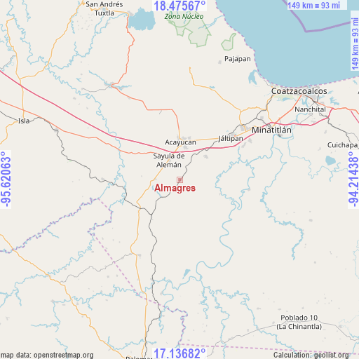
Almagres GPS coordinates[2]
17° 48' 27" North, 94° 55' 3" West
| Map corner | latitude | longitude |
|---|---|---|
| Upper-left | 18.47567°, | -95.62063° |
| Center: | 17.8075°, | -94.9175° |
| Lower-right: | 17.13682°, | -94.21438° |
| Map W x H: | 148.9×148.9 km | = 92.5×92.5mi |
| max Lat: | 32.7° ⇑80.5% North |
| Almagres: | 17.8075° |
| min Lat: | ⇓19.5% South 14.53588° |
| min Long | Almagres | max Long |
| -117.105° | -94.9175° | -86.73105° |
| W 84.8%⇐ | ⇒15.2% E |
Elevation
Elevation of Almagres is 37 m = 121 ft, and this is 1216.7 m = 3992 ft below average elevation for this country.
| Max E: |
3497 m = 11473 ft | 86.3% |
| Avg. | 1253.7 m = 4113 ft | |
| Almagres | 37 m = 121 ft | |
Min E: |
-1 m = -3 ft | 13.7% |
See also: Mexico elevation on elevation.city.
Geographical zone
Almagres is located in North Torrid zone (between Equator and Tropic of Cancer). Distance of this Northern Tropic circle is 625.9 km =388.9 mi to North.| Distance of | km | miles | from Almagres |
|---|---|---|---|
| North Pole | 8027.1 | 4987.8 | to North |
| Arctic Circle | 5421.2 | 3368.6 | to North |
| Tropic Cancer | 625.9 | 388.9 | to North |
| Equator | 1980 | 1230.3 | to South |


Nearby cities:
15 places around Almagres: (largest is in red/bold)
• Acayucan
15.8 km =9.8 mi,  1°
1°
• Aguilera
10.3 km =6.4 mi,  272°
272°
• Colonia Lealtad
17.4 km =10.8 mi,  5°
5°
• Congregación Hidalgo
15.5 km =9.6 mi,  338°
338°
• Cruz del Milagro
14.9 km =9.3 mi,  318°
318°
• Dehesa
17.2 km =10.7 mi,  330°
330°
• El Juile
10.4 km =6.5 mi,  227°
227°
• Francisco I. Madero
17.5 km =10.9 mi,  24°
24°
• La Caudalosa
15.9 km =9.9 mi,  275°
275°
• Nuevo Poblado el Hato
15.4 km =9.6 mi, 339°
• Oluta
13.8 km =8.6 mi, 9°
• San Lorenzo Tenochtitlán
17.6 km =10.9 mi,  109°
109°
• Sayula de Alemán
9.4 km =5.8 mi, 331°
• Tenejapa
10.8 km =6.7 mi,  28°
28°
• Texistepec
14.4 km =8.9 mi,  47°
47°
Sources, notices
• [Note1] Compared only with cities in Mexico existing in our database
• [Src1] Map data: © OpenStreetMap contributors (CC-BY-SA)
• [Src2] Other city data from geonames.org with taken over terms of usage.
• [Src3] Geographical zone / Annual Mean Temperature by Robert A. Rohde @ Wikipedia
