Achotal de Moreno geodata
Achotal de Moreno (Veracruz) is a populated place; located in Mexico in America/Mexico_City (GMT-6) time zone. With population of 1,505 people, there are 5734 cities with bigger population in this country. Compared to other cities in Mexico, 81.1% of cities are located further ↑North; 84.2% of cities are located further ←West and 85.1% of cities have higher elevation than Achotal de Moreno. Note1


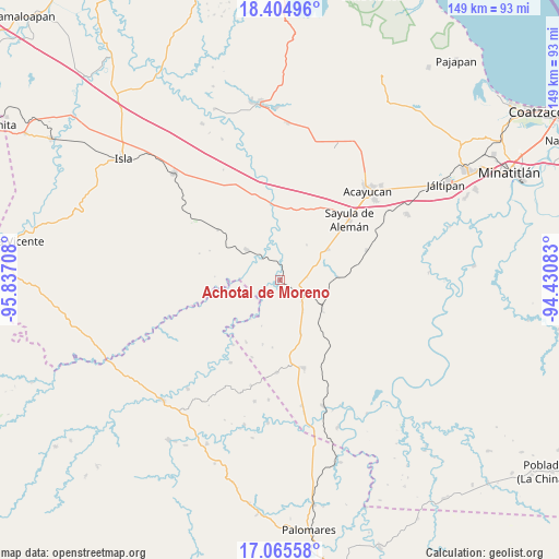
Achotal de Moreno GPS coordinates[2]
17° 44' 11.472" North, 95° 8' 2.22" West
| Map corner | latitude | longitude |
|---|---|---|
| Upper-left | 18.40496°, | -95.83708° |
| Center: | 17.73652°, | -95.13395° |
| Lower-right: | 17.06558°, | -94.43083° |
| Map W x H: | 148.9×148.9 km | = 92.5×92.5mi |
| max Lat: | 32.7° ⇑81.1% North |
| Achotal de Moreno: | 17.73652° |
| min Lat: | ⇓18.9% South 14.53588° |
| min Long | Achotal de More | max Long |
| -117.105° | -95.13395° | -86.73105° |
| W 84.2%⇐ | ⇒15.8% E |
Elevation
Elevation of Achotal de Moreno is 43 m = 141 ft, and this is 1210.7 m = 3972 ft below average elevation for this country.
| Max E: |
3497 m = 11473 ft | 85.1% |
| Avg. | 1253.7 m = 4113 ft | |
| Achotal de Moreno | 43 m = 141 ft | |
Min E: |
-1 m = -3 ft | 14.9% |
See also: Mexico elevation on elevation.city.
Geographical zone
Achotal de Moreno is located in North Torrid zone (between Equator and Tropic of Cancer). Distance of this Northern Tropic circle is 633.8 km =393.8 mi to North.| Distance of | km | miles | from Achotal de Moreno |
|---|---|---|---|
| North Pole | 8034.9 | 4992.7 | to North |
| Arctic Circle | 5429.1 | 3373.5 | to North |
| Tropic Cancer | 633.8 | 393.8 | to North |
| Equator | 1972.1 | 1225.4 | to South |


Nearby cities:
15 places around Achotal de Moreno: (largest is in red/bold)
• Aguilera
15.1 km =9.4 mi,  56°
56°
• Angostura
21.3 km =13.2 mi,  308°
308°
• Bellaco
7.5 km =4.7 mi,  318°
318°
• Campo Nuevo
7.5 km =4.7 mi,  119°
119°
• Chapopoapan
21.2 km =13.2 mi,  13°
13°
• Ejido Guadalupe Victoria
11.4 km =7.1 mi,  155°
155°
• Ejido Monte Verde
7.5 km =4.7 mi,  185°
185°
• El Juile
15.3 km =9.5 mi,  86°
86°
• Estación Juanita
12 km =7.5 mi, 312°
• La Caudalosa
11.7 km =7.3 mi,  36°
36°
• La Cerquilla
20.8 km =12.9 mi,  23°
23°
• Loma Bonita
15.1 km =9.4 mi, 159°
• Medias Aguas
13.5 km =8.4 mi, 124°
• Rancho Nuevo
20.2 km =12.6 mi, 16°
• San Juan Evangelista
16.6 km =10.3 mi,  357°
357°
Sources, notices
• [Note1] Compared only with cities in Mexico existing in our database
• [Src1] Map data: © OpenStreetMap contributors (CC-BY-SA)
• [Src2] Other city data from geonames.org with taken over terms of usage.
• [Src3] Geographical zone / Annual Mean Temperature by Robert A. Rohde @ Wikipedia
