Aguilera geodata
Aguilera (Veracruz) is a populated place; located in Mexico in America/Mexico_City (GMT-6) time zone. With population of 3,260 people, there are 2782 cities with bigger population in this country. Compared to other cities in Mexico, 80.4% of cities are located further ↑North; 84.6% of cities are located further ←West and 78.3% of cities have higher elevation than Aguilera. Note1


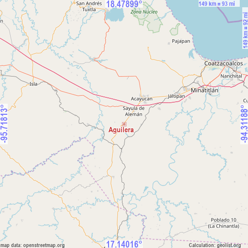
Aguilera GPS coordinates[2]
17° 48' 38.988" North, 95° 0' 54" West
| Map corner | latitude | longitude |
|---|---|---|
| Upper-left | 18.47899°, | -95.71813° |
| Center: | 17.81083°, | -95.015° |
| Lower-right: | 17.14016°, | -94.31188° |
| Map W x H: | 148.9×148.9 km | = 92.5×92.5mi |
| max Lat: | 32.7° ⇑80.4% North |
| Aguilera: | 17.81083° |
| min Lat: | ⇓19.6% South 14.53588° |
| min Long | Aguilera | max Long |
| -117.105° | -95.015° | -86.73105° |
| W 84.6%⇐ | ⇒15.4% E |
Elevation
Elevation of Aguilera is 125 m = 410 ft, and this is 1128.7 m = 3703 ft below average elevation for this country.
| Max E: |
3497 m = 11473 ft | 78.3% |
| Avg. | 1253.7 m = 4113 ft | |
| Aguilera | 125 m = 410 ft | |
Min E: |
-1 m = -3 ft | 21.7% |
See also: Mexico elevation on elevation.city.
Geographical zone
Aguilera is located in North Torrid zone (between Equator and Tropic of Cancer). Distance of this Northern Tropic circle is 625.5 km =388.7 mi to North.| Distance of | km | miles | from Aguilera |
|---|---|---|---|
| North Pole | 8026.7 | 4987.6 | to North |
| Arctic Circle | 5420.8 | 3368.3 | to North |
| Tropic Cancer | 625.5 | 388.7 | to North |
| Equator | 1980.4 | 1230.6 | to South |


Nearby cities:
15 places around Aguilera: (largest is in red/bold)
• Achotal de Moreno
15.1 km =9.4 mi,  236°
236°
• Almagres
10.3 km =6.4 mi,  92°
92°
• Campo Nuevo
13.4 km =8.3 mi,  206°
206°
• Chapopoapan
14.4 km =8.9 mi,  328°
328°
• Congregación Hidalgo
14.8 km =9.2 mi,  18°
18°
• Cruz del Milagro
10.8 km =6.7 mi,  2°
2°
• Dehesa
14.7 km =9.1 mi,  7°
7°
• El Juile
7.9 km =4.9 mi,  159°
159°
• La Caudalosa
5.7 km =3.5 mi,  281°
281°
• La Cerquilla
11.6 km =7.2 mi,  338°
338°
• Nuevo Poblado el Hato
14.8 km =9.2 mi, 19°
• Rancho Nuevo
13.1 km =8.1 mi, 328°
• San Juan Evangelista
15.6 km =9.7 mi,  302°
302°
• Sayula de Alemán
9.8 km =6.1 mi,  36°
36°
• Vista Hermosa
13.4 km =8.3 mi, 338°
Sources, notices
• [Note1] Compared only with cities in Mexico existing in our database
• [Src1] Map data: © OpenStreetMap contributors (CC-BY-SA)
• [Src2] Other city data from geonames.org with taken over terms of usage.
• [Src3] Geographical zone / Annual Mean Temperature by Robert A. Rohde @ Wikipedia
