El Súchil geodata
El Súchil (Veracruz) is a populated place; located in Mexico in America/Mexico_City (GMT-6) time zone. With population of 699 people, there are 12460 cities with bigger population in this country. Compared to other cities in Mexico, 83% of cities are located further ↑North; 84.6% of cities are located further ←West and 83.5% of cities have higher elevation than El Súchil. Note1


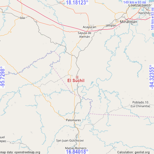
El Súchil GPS coordinates[2]
17° 30' 42.984" North, 95° 1' 36.012" West
| Map corner | latitude | longitude |
|---|---|---|
| Upper-left | 18.18123°, | -95.7298° |
| Center: | 17.51194°, | -95.02667° |
| Lower-right: | 16.84018°, | -94.32355° |
| Map W x H: | 149.1×149.1 km | = 92.6×92.6mi |
| max Lat: | 32.7° ⇑83% North |
| El Súchil: | 17.51194° |
| min Lat: | ⇓17% South 14.53588° |
| min Long | El Súchil | max Long |
| -117.105° | -95.02667° | -86.73105° |
| W 84.6%⇐ | ⇒15.4% E |
Elevation
Elevation of El Súchil is 56 m = 184 ft, and this is 1197.7 m = 3929 ft below average elevation for this country.
| Max E: |
3497 m = 11473 ft | 83.5% |
| Avg. | 1253.7 m = 4113 ft | |
| El Súchil | 56 m = 184 ft | |
Min E: |
-1 m = -3 ft | 16.5% |
See also: Mexico elevation on elevation.city.
Geographical zone
El Súchil is located in North Torrid zone (between Equator and Tropic of Cancer). Distance of this Northern Tropic circle is 658.8 km =409.4 mi to North.| Distance of | km | miles | from El Súchil |
|---|---|---|---|
| North Pole | 8059.9 | 5008.2 | to North |
| Arctic Circle | 5454 | 3389 | to North |
| Tropic Cancer | 658.8 | 409.4 | to North |
| Equator | 1947.1 | 1209.9 | to South |


Nearby cities:
15 places around El Súchil: (largest is in red/bold)
• Benito Juárez
19.7 km =12.2 mi,  248°
248°
• Campo Nuevo
21.8 km =13.5 mi,  347°
347°
• Coapiloloyita
10 km =6.2 mi,  165°
165°
• Ejido Guadalupe Victoria
16 km =9.9 mi,  335°
335°
• Ejido Monte Verde
21.3 km =13.2 mi,  325°
325°
• El Paraíso
12.3 km =7.6 mi,  272°
272°
• El Tepache
21.9 km =13.6 mi,  93°
93°
• Emiliano Zapata
19.6 km =12.2 mi,  260°
260°
• Jesús Carranza
8.5 km =5.3 mi,  179°
179°
• La Nueva Raza
16 km =9.9 mi, 245°
• Loma Bonita
12.4 km =7.7 mi, 331°
• Los Ángeles
19.6 km =12.2 mi,  228°
228°
• Medias Aguas
17.3 km =10.7 mi,  359°
359°
• Palo Dulce
10.1 km =6.3 mi,  213°
213°
• Suchilapan del Río
14.6 km =9.1 mi,  163°
163°
Sources, notices
• [Note1] Compared only with cities in Mexico existing in our database
• [Src1] Map data: © OpenStreetMap contributors (CC-BY-SA)
• [Src2] Other city data from geonames.org with taken over terms of usage.
• [Src3] Geographical zone / Annual Mean Temperature by Robert A. Rohde @ Wikipedia
