Nuevo Cantón geodata
Nuevo Cantón (Veracruz) is a populated place; located in Mexico in America/Mexico_City (GMT-6) time zone. With population of 742 people, there are 11790 cities with bigger population in this country. Compared to other cities in Mexico, 85% of cities are located further ↑North; 85.4% of cities are located further ←West and 80.6% of cities have higher elevation than Nuevo Cantón. Note1


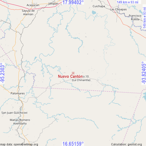
Nuevo Cantón GPS coordinates[2]
17° 19' 26.508" North, 94° 31' 37.812" West
| Map corner | latitude | longitude |
|---|---|---|
| Upper-left | 17.99402°, | -95.2303° |
| Center: | 17.32403°, | -94.52717° |
| Lower-right: | 16.65159°, | -93.82405° |
| Map W x H: | 149.3×149.3 km | = 92.8×92.8mi |
| max Lat: | 32.7° ⇑85% North |
| Nuevo Cantón: | 17.32403° |
| min Lat: | ⇓15% South 14.53588° |
| min Long | Nuevo Cantón | max Long |
| -117.105° | -94.52717° | -86.73105° |
| W 85.4%⇐ | ⇒14.6% E |
Elevation
Elevation of Nuevo Cantón is 86 m = 282 ft, and this is 1167.7 m = 3831 ft below average elevation for this country.
| Max E: |
3497 m = 11473 ft | 80.6% |
| Avg. | 1253.7 m = 4113 ft | |
| Nuevo Cantón | 86 m = 282 ft | |
Min E: |
-1 m = -3 ft | 19.4% |
See also: Mexico elevation on elevation.city.
Geographical zone
Nuevo Cantón is located in North Torrid zone (between Equator and Tropic of Cancer). Distance of this Northern Tropic circle is 679.7 km =422.3 mi to North.| Distance of | km | miles | from Nuevo Cantón |
|---|---|---|---|
| North Pole | 8080.8 | 5021.2 | to North |
| Arctic Circle | 5474.9 | 3401.9 | to North |
| Tropic Cancer | 679.7 | 422.3 | to North |
| Equator | 1926.3 | 1196.9 | to South |


Nearby cities:
15 places around Nuevo Cantón: (largest is in red/bold)
• Cahuapan (Anexo Niños Héroes)
14.6 km =9.1 mi,  349°
349°
• Helio García Alfaro
26.3 km =16.3 mi,  105°
105°
• Hermanos Cedillo
12 km =7.5 mi,  228°
228°
• Jorge L. Tamayo (Poblado Dos)
15.8 km =9.8 mi,  236°
236°
• La Breña
24.4 km =15.2 mi,  37°
37°
• La Chinantla
9.7 km =6 mi,  122°
122°
• La Laguna
6.5 km =4 mi,  155°
155°
• Las Carolinas
9.7 km =6 mi,  86°
86°
• Modelo Dos Ríos
26.5 km =16.5 mi,  287°
287°
• Niños Héroes
12.7 km =7.9 mi,  13°
13°
• Paso del Moral
12.4 km =7.7 mi,  217°
217°
• Plan de Arroyo
12.5 km =7.8 mi, 225°
• Poblado 10
9.5 km =5.9 mi, 123°
• Poblado Cinco
6.1 km =3.8 mi,  205°
205°
• Vicente Guerrero
28 km =17.4 mi,  313°
313°
Sources, notices
• [Note1] Compared only with cities in Mexico existing in our database
• [Src1] Map data: © OpenStreetMap contributors (CC-BY-SA)
• [Src2] Other city data from geonames.org with taken over terms of usage.
• [Src3] Geographical zone / Annual Mean Temperature by Robert A. Rohde @ Wikipedia
