Plan de Arroyo geodata
Plan de Arroyo (Veracruz) is a populated place; located in Mexico in America/Mexico_City (GMT-6) time zone. With population of 747 people, there are 11723 cities with bigger population in this country. Compared to other cities in Mexico, 86% of cities are located further ↑North; 85.3% of cities are located further ←West and 81.9% of cities have higher elevation than Plan de Arroyo. Note1


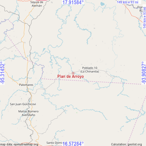
Plan de Arroyo GPS coordinates[2]
17° 14' 44.016" North, 94° 36' 41.004" West
| Map corner | latitude | longitude |
|---|---|---|
| Upper-left | 17.91584°, | -95.31452° |
| Center: | 17.24556°, | -94.61139° |
| Lower-right: | 16.57284°, | -93.90827° |
| Map W x H: | 149.3×149.3 km | = 92.8×92.8mi |
| max Lat: | 32.7° ⇑86% North |
| Plan de Arroyo: | 17.24556° |
| min Lat: | ⇓14% South 14.53588° |
| min Long | Plan de Arroyo | max Long |
| -117.105° | -94.61139° | -86.73105° |
| W 85.3%⇐ | ⇒14.7% E |
Elevation
Elevation of Plan de Arroyo is 71 m = 233 ft, and this is 1182.7 m = 3880 ft below average elevation for this country.
| Max E: |
3497 m = 11473 ft | 81.9% |
| Avg. | 1253.7 m = 4113 ft | |
| Plan de Arroyo | 71 m = 233 ft | |
Min E: |
-1 m = -3 ft | 18.1% |
See also: Mexico elevation on elevation.city.
Geographical zone
Plan de Arroyo is located in North Torrid zone (between Equator and Tropic of Cancer). Distance of this Northern Tropic circle is 688.4 km =427.8 mi to North.| Distance of | km | miles | from Plan de Arroyo |
|---|---|---|---|
| North Pole | 8089.5 | 5026.6 | to North |
| Arctic Circle | 5483.6 | 3407.4 | to North |
| Tropic Cancer | 688.4 | 427.8 | to North |
| Equator | 1917.5 | 1191.5 | to South |


Nearby cities:
15 places around Plan de Arroyo: (largest is in red/bold)
• Cahuapan (Anexo Niños Héroes)
23.9 km =14.9 mi,  15°
15°
• Hermanos Cedillo
0.7 km =0.4 mi,  0°
0°
• Jorge L. Tamayo (Poblado Dos)
4.2 km =2.6 mi,  270°
270°
• La Chinantla
17.6 km =10.9 mi,  78°
78°
• La Esmeralda
20.7 km =12.9 mi,  244°
244°
• La Laguna
12 km =7.5 mi, 76°
• Las Carolinas
20.8 km =12.9 mi,  63°
63°
• Modelo Dos Ríos
23.4 km =14.5 mi,  315°
315°
• Niños Héroes
24.2 km =15 mi,  29°
29°
• Nuevo Cantón
12.5 km =7.8 mi,  45°
45°
• Paso del Moral
1.7 km =1.1 mi,  129°
129°
• Poblado 10
17.3 km =10.7 mi, 78°
• Poblado Cinco
7.1 km =4.4 mi, 63°
• Veinticuatro
22.2 km =13.8 mi, 268°
• Vicente Guerrero
30.1 km =18.7 mi,  337°
337°
Sources, notices
• [Note1] Compared only with cities in Mexico existing in our database
• [Src1] Map data: © OpenStreetMap contributors (CC-BY-SA)
• [Src2] Other city data from geonames.org with taken over terms of usage.
• [Src3] Geographical zone / Annual Mean Temperature by Robert A. Rohde @ Wikipedia
