San Jerónimo Bonchete geodata
San Jerónimo Bonchete (State of Mexico) is a populated place; located in Mexico in America/Mexico_City (GMT-6) time zone. With population of 2,564 people, there are 3452 cities with bigger population in this country. Compared to other cities in Mexico, 51.3% of cities are located further ↑North; 63.3% of cities are located further →East and 98.3% of cities have lower elevation than San Jerónimo Bonchete. Note1


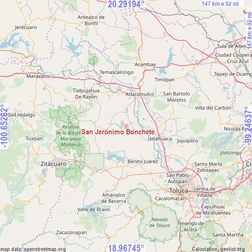
San Jerónimo Bonchete GPS coordinates[2]
19° 37' 51.816" North, 99° 56' 58.164" West
| Map corner | latitude | longitude |
|---|---|---|
| Upper-left | 20.29194°, | -100.65262° |
| Center: | 19.63106°, | -99.94949° |
| Lower-right: | 18.96745°, | -99.24637° |
| Map W x H: | 147.3×147.3 km | = 91.5×91.5mi |
| max Lat: | 32.7° ⇑51.3% North |
| San Jerónimo Bonchete: | 19.63106° |
| min Lat: | ⇓48.7% South 14.53588° |
| min Long | San Jerónimo B | max Long |
| -117.105° | -99.94949° | -86.73105° |
| W 36.7%⇐ | ⇒63.3% E |
Elevation
Elevation of San Jerónimo Bonchete is 2769 m = 9085 ft, and this is 1515.3 m = 4971 ft above average elevation for this country.
| Max E: |
3497 m = 11473 ft | 1.7% |
| San Jerónimo Bonchete | 2769 m 9085 ft | |
| Avg. | 1253.7 m = 4113 ft | |
Min E: |
-1 m = -3 ft | 98.3% |
See also: Mexico elevation on elevation.city.
Geographical zone
San Jerónimo Bonchete is located in North Torrid zone (between Equator and Tropic of Cancer). Distance of this Northern Tropic circle is 423.1 km =262.9 mi to North.| Distance of | km | miles | from San Jerónimo Bonchete |
|---|---|---|---|
| North Pole | 7824.3 | 4861.8 | to North |
| Arctic Circle | 5218.4 | 3242.6 | to North |
| Tropic Cancer | 423.1 | 262.9 | to North |
| Equator | 2182.8 | 1356.3 | to South |


Nearby cities:
15 places around San Jerónimo Bonchete: (largest is in red/bold)
• Barrio Tepetitlán Emilio Portes Gil
7 km =4.3 mi,  69°
69°
• Calvario del Carmen
6.4 km =4 mi,  274°
274°
• Dolores Hidalgo
3.6 km =2.2 mi,  41°
41°
• El Carmen Ocotepec
6.8 km =4.2 mi,  337°
337°
• Emilio Portes Gil
3.7 km =2.3 mi, 66°
• Estutempan
4.4 km =2.7 mi,  301°
301°
• Guadalupe Coté
4.4 km =2.7 mi,  238°
238°
• San Agustín Mextepec
2.4 km =1.5 mi,  85°
85°
• San Antonio Mextepec
2.7 km =1.7 mi,  1°
1°
• San Jerónimo Mavatí
3 km =1.9 mi,  170°
170°
• San Juan Cote Ejido
3.1 km =1.9 mi,  199°
199°
• San Lucas Ocotepec
5.8 km =3.6 mi, 335°
• San Pedro el Chico
4.3 km =2.7 mi,  105°
105°
• Santa Ana Nichi Ejido
6.6 km =4.1 mi,  218°
218°
• Santa Cruz Mextepec
3.2 km =2 mi,  353°
353°
Sources, notices
• [Note1] Compared only with cities in Mexico existing in our database
• [Src1] Map data: © OpenStreetMap contributors (CC-BY-SA)
• [Src2] Other city data from geonames.org with taken over terms of usage.
• [Src3] Geographical zone / Annual Mean Temperature by Robert A. Rohde @ Wikipedia
