San Antonio Mextepec geodata
San Antonio Mextepec (State of Mexico) is a populated place; located in Mexico in America/Mexico_City (GMT-6) time zone. With population of 973 people, there are 8931 cities with bigger population in this country. Compared to other cities in Mexico, 50.7% of cities are located further ↑North; 63.3% of cities are located further →East and 93.9% of cities have lower elevation than San Antonio Mextepec. Note1


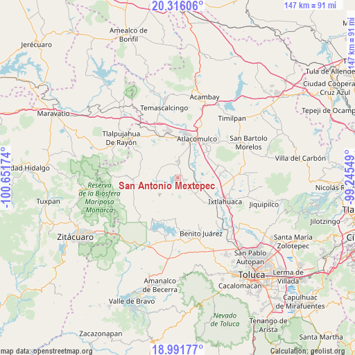
San Antonio Mextepec GPS coordinates[2]
19° 39' 19.008" North, 99° 56' 54.996" West
| Map corner | latitude | longitude |
|---|---|---|
| Upper-left | 20.31606°, | -100.65174° |
| Center: | 19.65528°, | -99.94861° |
| Lower-right: | 18.99177°, | -99.24549° |
| Map W x H: | 147.2×147.2 km | = 91.5×91.5mi |
| max Lat: | 32.7° ⇑50.7% North |
| San Antonio Mextepec: | 19.65528° |
| min Lat: | ⇓49.3% South 14.53588° |
| min Long | San Antonio Mex | max Long |
| -117.105° | -99.94861° | -86.73105° |
| W 36.7%⇐ | ⇒63.3% E |
Elevation
Elevation of San Antonio Mextepec is 2567 m = 8422 ft, and this is 1313.3 m = 4309 ft above average elevation for this country.
| Max E: |
3497 m = 11473 ft | 6.1% |
| San Antonio Mextepec | 2567 m 8422 ft | |
| Avg. | 1253.7 m = 4113 ft | |
Min E: |
-1 m = -3 ft | 93.9% |
See also: Mexico elevation on elevation.city.
Geographical zone
San Antonio Mextepec is located in North Torrid zone (between Equator and Tropic of Cancer). Distance of this Northern Tropic circle is 420.5 km =261.3 mi to North.| Distance of | km | miles | from San Antonio Mextepec |
|---|---|---|---|
| North Pole | 7821.6 | 4860.1 | to North |
| Arctic Circle | 5215.7 | 3240.9 | to North |
| Tropic Cancer | 420.5 | 261.3 | to North |
| Equator | 2185.5 | 1358 | to South |


Nearby cities:
15 places around San Antonio Mextepec: (largest is in red/bold)
• Calvario Buenavista
5.5 km =3.4 mi,  351°
351°
• Dolores Hidalgo
2.3 km =1.4 mi,  90°
90°
• Ejido de San Juan Jalpa
5.7 km =3.5 mi,  43°
43°
• El Carmen Ocotepec
4.4 km =2.7 mi,  323°
323°
• Emilio Portes Gil
3.6 km =2.2 mi,  109°
109°
• Estutempan
3.9 km =2.4 mi,  264°
264°
• La Cabecera Concepción
5.4 km =3.4 mi,  8°
8°
• Palmillas
4.3 km =2.7 mi,  357°
357°
• San Agustín Mextepec
3.4 km =2.1 mi,  137°
137°
• San Jerónimo Bonchete
2.7 km =1.7 mi,  181°
181°
• San Jerónimo Mavatí
5.7 km =3.5 mi, 176°
• San Juan Jalpa Centro
5.1 km =3.2 mi,  22°
22°
• San Lucas Ocotepec
3.5 km =2.2 mi, 316°
• San Pedro el Chico
5.6 km =3.5 mi,  133°
133°
• Santa Cruz Mextepec
0.7 km =0.4 mi, 316°
Sources, notices
• [Note1] Compared only with cities in Mexico existing in our database
• [Src1] Map data: © OpenStreetMap contributors (CC-BY-SA)
• [Src2] Other city data from geonames.org with taken over terms of usage.
• [Src3] Geographical zone / Annual Mean Temperature by Robert A. Rohde @ Wikipedia
