Calvario Buenavista geodata
Calvario Buenavista (State of Mexico) is a populated place; located in Mexico in America/Mexico_City (GMT-6) time zone. With population of 1,928 people, there are 4510 cities with bigger population in this country. Compared to other cities in Mexico, 50.6% of cities are located further ↓South; 63.4% of cities are located further →East and 96.4% of cities have lower elevation than Calvario Buenavista. Note1


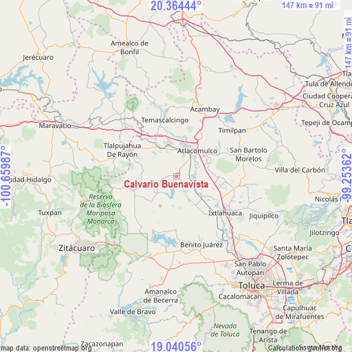
Calvario Buenavista GPS coordinates[2]
19° 42' 13.932" North, 99° 57' 24.264" West
| Map corner | latitude | longitude |
|---|---|---|
| Upper-left | 20.36444°, | -100.65987° |
| Center: | 19.70387°, | -99.95674° |
| Lower-right: | 19.04056°, | -99.25362° |
| Map W x H: | 147.2×147.2 km | = 91.5×91.5mi |
| max Lat: | 32.7° ⇑49.4% North |
| Calvario Buenavista: | 19.70387° |
| min Lat: | ⇓50.6% South 14.53588° |
| min Long | Calvario Buenav | max Long |
| -117.105° | -99.95674° | -86.73105° |
| W 36.6%⇐ | ⇒63.4% E |
Elevation
Elevation of Calvario Buenavista is 2646 m = 8681 ft, and this is 1392.3 m = 4568 ft above average elevation for this country.
| Max E: |
3497 m = 11473 ft | 3.6% |
| Calvario Buenavista | 2646 m 8681 ft | |
| Avg. | 1253.7 m = 4113 ft | |
Min E: |
-1 m = -3 ft | 96.4% |
See also: Mexico elevation on elevation.city.
Geographical zone
Calvario Buenavista is located in North Torrid zone (between Equator and Tropic of Cancer). Distance of this Northern Tropic circle is 415.1 km =257.9 mi to North.| Distance of | km | miles | from Calvario Buenavista |
|---|---|---|---|
| North Pole | 7816.2 | 4856.8 | to North |
| Arctic Circle | 5210.3 | 3237.5 | to North |
| Tropic Cancer | 415.1 | 257.9 | to North |
| Equator | 2190.9 | 1361.4 | to South |


Nearby cities:
15 places around Calvario Buenavista: (largest is in red/bold)
• Barrio Santa Cruz de San Pablo Tlalchichilpa
2.7 km =1.7 mi,  283°
283°
• Dolores Hidalgo
6.3 km =3.9 mi,  149°
149°
• Ejido de San Juan Jalpa
5 km =3.1 mi,  105°
105°
• El Carmen Ocotepec
2.6 km =1.6 mi,  224°
224°
• El Obraje
2.2 km =1.4 mi,  343°
343°
• Estutempan
6.5 km =4 mi,  207°
207°
• La Cabecera Concepción
1.6 km =1 mi,  91°
91°
• Palmillas
1.3 km =0.8 mi, 149°
• Purísima Concepción Mayorazgo
4.9 km =3 mi,  253°
253°
• San Antonio Mextepec
5.5 km =3.4 mi,  171°
171°
• San Felipe del Progreso
1.3 km =0.8 mi,  23°
23°
• San Juan Coajomulco
5.6 km =3.5 mi,  347°
347°
• San Juan Jalpa Centro
2.9 km =1.8 mi,  102°
102°
• San Lucas Ocotepec
3.3 km =2.1 mi, 209°
• Santa Cruz Mextepec
4.9 km =3 mi,  175°
175°
Sources, notices
• [Note1] Compared only with cities in Mexico existing in our database
• [Src1] Map data: © OpenStreetMap contributors (CC-BY-SA)
• [Src2] Other city data from geonames.org with taken over terms of usage.
• [Src3] Geographical zone / Annual Mean Temperature by Robert A. Rohde @ Wikipedia
