San Pedro Atocpan geodata
San Pedro Atocpan (Mexico City) is a populated place; located in Mexico in America/Mexico_City (GMT-6) time zone. With population of 8,283 people, there are 1148 cities with bigger population in this country. Compared to other cities in Mexico, 61.2% of cities are located further ↑North; 50.5% of cities are located further →East and 91.3% of cities have lower elevation than San Pedro Atocpan. Note1


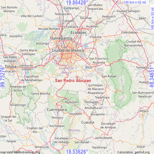
San Pedro Atocpan GPS coordinates[2]
19° 12' 5.76" North, 99° 2' 58.668" West
| Map corner | latitude | longitude |
|---|---|---|
| Upper-left | 19.86426°, | -99.75276° |
| Center: | 19.2016°, | -99.04963° |
| Lower-right: | 18.53626°, | -98.34651° |
| Map W x H: | 147.7×147.7 km | = 91.8×91.8mi |
| max Lat: | 32.7° ⇑61.2% North |
| San Pedro Atocpan: | 19.2016° |
| min Lat: | ⇓38.8% South 14.53588° |
| min Long | San Pedro Atocp | max Long |
| -117.105° | -99.04963° | -86.73105° |
| W 49.5%⇐ | ⇒50.5% E |
Elevation
Elevation of San Pedro Atocpan is 2455 m = 8054 ft, and this is 1201.3 m = 3941 ft above average elevation for this country.
| Max E: |
3497 m = 11473 ft | 8.7% |
| San Pedro Atocpan | 2455 m 8054 ft | |
| Avg. | 1253.7 m = 4113 ft | |
Min E: |
-1 m = -3 ft | 91.3% |
See also: Mexico elevation on elevation.city.
Geographical zone
San Pedro Atocpan is located in North Torrid zone (between Equator and Tropic of Cancer). Distance of this Northern Tropic circle is 470.9 km =292.6 mi to North.| Distance of | km | miles | from San Pedro Atocpan |
|---|---|---|---|
| North Pole | 7872 | 4891.4 | to North |
| Arctic Circle | 5266.2 | 3272.3 | to North |
| Tropic Cancer | 470.9 | 292.6 | to North |
| Equator | 2135 | 1326.6 | to South |


Nearby cities:
15 places around San Pedro Atocpan: (largest is in red/bold)
• Milpa Alta
3 km =1.9 mi,  109°
109°
• San Andrés Mixquic
9.4 km =5.8 mi,  73°
73°
• San Antonio Tecómitl
6.7 km =4.2 mi, 74°
• San Bartolome Xicomulco
2 km =1.2 mi,  284°
284°
• San Francisco Tecoxpa
4.7 km =2.9 mi,  103°
103°
• San Isidro Cuatepec
4.8 km =3 mi, 66°
• San Juan Ixtayopan
6.3 km =3.9 mi,  57°
57°
• San Juan y San Pedro Tezompa
9.4 km =5.8 mi,  86°
86°
• San Lorenzo Tlacoyucan
3.4 km =2.1 mi,  147°
147°
• San Miguel Topilejo
9.7 km =6 mi,  270°
270°
• San Pablo Oztotepec
3 km =1.9 mi,  236°
236°
• San Salvador Cuauhtenco
4.3 km =2.7 mi,  256°
256°
• Santa Ana Tlacotenco
6.2 km =3.9 mi,  117°
117°
• Tetelco
8.2 km =5.1 mi,  78°
78°
• Xochimilco
8.2 km =5.1 mi,  316°
316°
Sources, notices
• [Note1] Compared only with cities in Mexico existing in our database
• [Src1] Map data: © OpenStreetMap contributors (CC-BY-SA)
• [Src2] Other city data from geonames.org with taken over terms of usage.
• [Src3] Geographical zone / Annual Mean Temperature by Robert A. Rohde @ Wikipedia
