San Juan y San Pedro Tezompa geodata
San Juan y San Pedro Tezompa (State of Mexico) is a populated place; located in Mexico in America/Mexico_City (GMT-6) time zone. With population of 11,819 people, there are 815 cities with bigger population in this country. Compared to other cities in Mexico, 61% of cities are located further ↑North; 50.8% of cities are located further ←West and 84.5% of cities have lower elevation than San Juan y San Pedro Tezompa. Note1
Current local time in San Juan y San Pedro Tezompa:
08:30 AM, WednesdayDifference from your time zone: hours


San Juan y San Pedro Tezompa GPS coordinates[2]
19° 12' 24.48" North, 98° 57' 38.628" West
| Map corner | latitude | longitude |
|---|---|---|
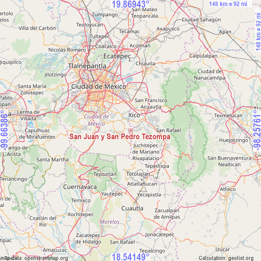
| Upper-left | 19.86943°, | -99.66386° |
| Center: | 19.2068°, | -98.96073° |
| Lower-right: | 18.54149°, | -98.25761° |
| Map W x H: | 147.7×147.7 km | = 91.8×91.8mi |
| max Lat: | 32.7° ⇑61% North |
| San Juan y San Pedro Tezompa: | 19.2068° |
| min Lat: | ⇓39% South 14.53588° |
| min Long | San Juan y San | max Long |
| -117.105° | -98.96073° | -86.73105° |
| W 50.8%⇐ | ⇒49.2% E |
Elevation
Elevation of San Juan y San Pedro Tezompa is 2251 m = 7385 ft, and this is 997.3 m = 3272 ft above average elevation for this country.
| Max E: |
3497 m = 11473 ft | 15.5% |
| San Juan y San Pedro Tezompa | 2251 m 7385 ft | |
| Avg. | 1253.7 m = 4113 ft | |
Min E: |
-1 m = -3 ft | 84.5% |
See also: Mexico elevation on elevation.city.
Geographical zone
San Juan y San Pedro Tezompa is located in North Torrid zone (between Equator and Tropic of Cancer). Distance of this Northern Tropic circle is 470.3 km =292.2 mi to North.| Distance of | km | miles | from San Juan y San Pedro Tezompa |
|---|---|---|---|
| North Pole | 7871.5 | 4891.1 | to North |
| Arctic Circle | 5265.6 | 3271.9 | to North |
| Tropic Cancer | 470.3 | 292.2 | to North |
| Equator | 2135.6 | 1327 | to South |


Nearby cities:
15 places around San Juan y San Pedro Tezompa: (largest is in red/bold)
• Barrio de Guadalupe
4.1 km =2.5 mi,  49°
49°
• Caserío de Cortés
1.1 km =0.7 mi,  144°
144°
• Colonia Michoacana
5.2 km =3.2 mi,  92°
92°
• Lomas de San Pablo
4.5 km =2.8 mi,  96°
96°
• San Andrés Mixquic
2.1 km =1.3 mi,  350°
350°
• San Antonio Tecómitl
3.1 km =1.9 mi,  293°
293°
• San Francisco Tecoxpa
5.1 km =3.2 mi,  250°
250°
• San Ignacio de Loyola
1.1 km =0.7 mi,  21°
21°
• San Isidro Cuatepec
5.1 km =3.2 mi, 285°
• San Juan Ixtayopan
4.9 km =3 mi,  304°
304°
• San Mateo Huitzilzingo
4.5 km =2.8 mi,  56°
56°
• San Pablo Atlazalpan
5.7 km =3.5 mi,  78°
78°
• Santa Ana Tlacotenco
5.2 km =3.2 mi,  228°
228°
• Santa Catarina Ayotzingo
3.3 km =2.1 mi, 84°
• Tetelco
1.7 km =1.1 mi,  310°
310°
Sources, notices
• [Note1] Compared only with cities in Mexico existing in our database
• [Src1] Map data: © OpenStreetMap contributors (CC-BY-SA)
• [Src2] Other city data from geonames.org with taken over terms of usage.
• [Src3] Geographical zone / Annual Mean Temperature by Robert A. Rohde @ Wikipedia
