Rosario geodata
Rosario (Sonora) is a populated place; located in Mexico in America/Hermosillo (GMT-7) time zone. With population of 2,815 people, there are 3153 cities with bigger population in this country. Compared to other cities in Mexico, 97.1% of cities are located further ↓South; 97.4% of cities are located further →East and 69.9% of cities have higher elevation than Rosario. Note1


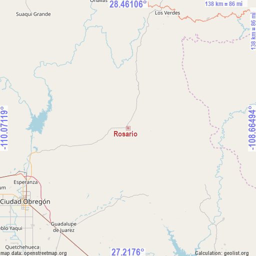
Rosario GPS coordinates[2]
27° 50' 27.996" North, 109° 22' 5.016" West
| Map corner | latitude | longitude |
|---|---|---|
| Upper-left | 28.46106°, | -110.07119° |
| Center: | 27.84111°, | -109.36806° |
| Lower-right: | 27.2176°, | -108.66494° |
| Map W x H: | 138.3×138.3 km | = 85.9×85.9mi |
| max Lat: | 32.7° ⇑2.9% North |
| Rosario: | 27.84111° |
| min Lat: | ⇓97.1% South 14.53588° |
| min Long | Rosario | max Long |
| -117.105° | -109.36806° | -86.73105° |
| W 2.6%⇐ | ⇒97.4% E |
Elevation
Elevation of Rosario is 423 m = 1388 ft, and this is 830.7 m = 2725 ft below average elevation for this country.
| Max E: |
3497 m = 11473 ft | 69.9% |
| Avg. | 1253.7 m = 4113 ft | |
| Rosario | 423 m = 1388 ft | |
Min E: |
-1 m = -3 ft | 30.1% |
See also: Mexico elevation on elevation.city.
Geographical zone
Rosario is located in North temperate zone (between Tropic of Cancer and the Arctic Circle). Distance of this Northern Tropic circle is 489.7 km =304.3 mi to South.| Distance of | km | miles | from Rosario |
|---|---|---|---|
| North Pole | 6911.4 | 4294.5 | to North |
| Arctic Circle | 4305.5 | 2675.3 | to North |
| Tropic Cancer | 489.7 | 304.3 | to South |
| Equator | 3095.6 | 1923.5 | to South |


Nearby cities:
15 places around Rosario: (largest is in red/bold)
• Batacosa
34.7 km =21.6 mi,  185°
185°
• Ciudad Obregón
68.8 km =42.8 mi,  235°
235°
• Cocorit
65.3 km =40.6 mi, 243°
• Esperanza
62.5 km =38.8 mi, 242°
• Estación Corral
63.4 km =39.4 mi,  248°
248°
• Etchohuaquila
69.6 km =43.2 mi,  213°
213°
• Francisco Villa
68.1 km =42.3 mi,  219°
219°
• Fundición
67.3 km =41.8 mi, 212°
• Loma de Guamúchil
66.1 km =41.1 mi, 247°
• Los Hornos
54.5 km =33.9 mi, 254°
• Onavas
70.7 km =43.9 mi,  347°
347°
• Quiriego
37.5 km =23.3 mi,  162°
162°
• San Bernardo
71.3 km =44.3 mi,  133°
133°
• Vicente Guerrero
68.8 km =42.8 mi, 240°
• Zona de Granjas (Granjas Mica)
60.2 km =37.4 mi,  234°
234°
Sources, notices
• [Note1] Compared only with cities in Mexico existing in our database
• [Src1] Map data: © OpenStreetMap contributors (CC-BY-SA)
• [Src2] Other city data from geonames.org with taken over terms of usage.
• [Src3] Geographical zone / Annual Mean Temperature by Robert A. Rohde @ Wikipedia
