Onavas geodata
Onavas (Sonora) is a seat of a second-order administrative division; located in Mexico in America/Hermosillo (GMT-7) time zone. With population of 361 people, there are 16856 cities with bigger population in this country. Compared to other cities in Mexico, 97.8% of cities are located further ↓South; 97.5% of cities are located further →East and 76.3% of cities have higher elevation than Onavas. Note1


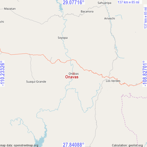
Onavas GPS coordinates[2]
28° 27' 38.988" North, 109° 31' 48.468" West
| Map corner | latitude | longitude |
|---|---|---|
| Upper-left | 29.07716°, | -110.23326° |
| Center: | 28.46083°, | -109.53013° |
| Lower-right: | 27.84088°, | -108.82701° |
| Map W x H: | 137.5×137.5 km | = 85.4×85.4mi |
| max Lat: | 32.7° ⇑2.2% North |
| Onavas: | 28.46083° |
| min Lat: | ⇓97.8% South 14.53588° |
| min Long | Onavas | max Long |
| -117.105° | -109.53013° | -86.73105° |
| W 2.5%⇐ | ⇒97.5% E |
Elevation
Elevation of Onavas is 175 m = 574 ft, and this is 1078.7 m = 3539 ft below average elevation for this country.
| Max E: |
3497 m = 11473 ft | 76.3% |
| Avg. | 1253.7 m = 4113 ft | |
| Onavas | 175 m = 574 ft | |
Min E: |
-1 m = -3 ft | 23.7% |
See also: Mexico elevation on elevation.city.
Geographical zone
Onavas is located in North temperate zone (between Tropic of Cancer and the Arctic Circle). Distance of this Northern Tropic circle is 558.6 km =347.1 mi to South.| Distance of | km | miles | from Onavas |
|---|---|---|---|
| North Pole | 6842.5 | 4251.7 | to North |
| Arctic Circle | 4236.6 | 2632.5 | to North |
| Tropic Cancer | 558.6 | 347.1 | to South |
| Equator | 3164.5 | 1966.3 | to South |


Nearby cities:
15 places around Onavas: (largest is in red/bold)
• Arivechi
61.8 km =38.4 mi,  32°
32°
• Bacanora
59.3 km =36.8 mi,  12°
12°
• Estación Corral
101.9 km =63.3 mi,  204°
204°
• Los Hornos
90.8 km =56.4 mi, 203°
• Maycoba
85.5 km =53.1 mi,  95°
95°
• Mazatán
84.7 km =52.6 mi,  315°
315°
• Rosario
70.7 km =43.9 mi,  167°
167°
• Sahuaripa
72 km =44.7 mi,  23°
23°
• San Javier
25.4 km =15.8 mi,  306°
306°
• San Pedro de la Cueva
94 km =58.4 mi,  347°
347°
• Soyopa
35.2 km =21.9 mi,  343°
343°
• Suaqui Grande
35.8 km =22.2 mi,  257°
257°
• Tecoripa
45.2 km =28.1 mi,  293°
293°
• Villa Pesqueira
84.6 km =52.6 mi,  329°
329°
• Yécora
59.7 km =37.1 mi, 99°
Sources, notices
• [Note1] Compared only with cities in Mexico existing in our database
• [Src1] Map data: © OpenStreetMap contributors (CC-BY-SA)
• [Src2] Other city data from geonames.org with taken over terms of usage.
• [Src3] Geographical zone / Annual Mean Temperature by Robert A. Rohde @ Wikipedia
