General Enrique Estrada geodata
General Enrique Estrada (Zacatecas) is a seat of a second-order administrative division; located in Mexico in America/Mexico_City (GMT-6) time zone. With population of 3,887 people, there are 2352 cities with bigger population in this country. Compared to other cities in Mexico, 88% of cities are located further ↓South; 85% of cities are located further →East and 80.4% of cities have lower elevation than General Enrique Estrada. Note1
Current local time in General Enrique Estrada:
08:29 AM, WednesdayDifference from your time zone: hours


General Enrique Estrada GPS coordinates[2]
22° 59' 50.892" North, 102° 44' 33.18" West
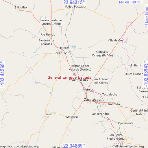
| Map corner | latitude | longitude |
|---|---|---|
| Upper-left | 23.64315°, | -103.44568° |
| Center: | 22.99747°, | -102.74255° |
| Lower-right: | 22.34869°, | -102.03943° |
| Map W x H: | 143.9×143.9 km | = 89.4×89.4mi |
| max Lat: | 32.7° ⇑12% North |
| General Enrique Estrada: | 22.99747° |
| min Lat: | ⇓88% South 14.53588° |
| min Long | General Enrique | max Long |
| -117.105° | -102.74255° | -86.73105° |
| W 15%⇐ | ⇒85% E |
Elevation
Elevation of General Enrique Estrada is 2151 m = 7057 ft, and this is 897.3 m = 2944 ft above average elevation for this country.
| Max E: |
3497 m = 11473 ft | 19.6% |
| General Enrique Estrada | 2151 m 7057 ft | |
| Avg. | 1253.7 m = 4113 ft | |
Min E: |
-1 m = -3 ft | 80.4% |
See also: Mexico elevation on elevation.city.
Geographical zone
General Enrique Estrada is located in North Torrid zone (between Equator and Tropic of Cancer). Distance of this Northern Tropic circle is 48.8 km =30.3 mi to North.| Distance of | km | miles | from General Enrique Estrada |
|---|---|---|---|
| North Pole | 7450 | 4629.2 | to North |
| Arctic Circle | 4844.1 | 3010 | to North |
| Tropic Cancer | 48.8 | 30.3 | to North |
| Equator | 2557.1 | 1588.9 | to South |


Nearby cities:
15 places around General Enrique Estrada: (largest is in red/bold)
• Adjuntas del Peñasco (El Peñasco)
10.1 km =6.3 mi,  266°
266°
• Estación San José
21.8 km =13.5 mi,  348°
348°
• Fraccionamiento San Felipe
21.4 km =13.3 mi,  341°
341°
• Francisco I. Madero
22.5 km =14 mi,  173°
173°
• Fresnillo
24.3 km =15.1 mi,  327°
327°
• Hacienda Nueva
23.6 km =14.7 mi,  144°
144°
• Hacienda Toribio
11.3 km =7 mi,  32°
32°
• Laguna Seca
23.4 km =14.5 mi, 346°
• Las Catarinas
16.6 km =10.3 mi,  51°
51°
• Las Pilas
22 km =13.7 mi, 142°
• Morelos
20.2 km =12.6 mi, 138°
• Pozos de Gamboa
18.5 km =11.5 mi,  107°
107°
• Río Frío
10.3 km =6.4 mi,  217°
217°
• Santiaguillo
19 km =11.8 mi, 28°
• Víctor Rosales
6.8 km =4.2 mi, 142°
Sources, notices
• [Note1] Compared only with cities in Mexico existing in our database
• [Src1] Map data: © OpenStreetMap contributors (CC-BY-SA)
• [Src2] Other city data from geonames.org with taken over terms of usage.
• [Src3] Geographical zone / Annual Mean Temperature by Robert A. Rohde @ Wikipedia
