Morelos geodata
Morelos (Zacatecas) is a seat of a second-order administrative division; located in Mexico in America/Mexico_City (GMT-6) time zone. With population of 6,602 people, there are 1420 cities with bigger population in this country. Compared to other cities in Mexico, 87.7% of cities are located further ↓South; 84.5% of cities are located further →East and 87% of cities have lower elevation than Morelos. Note1


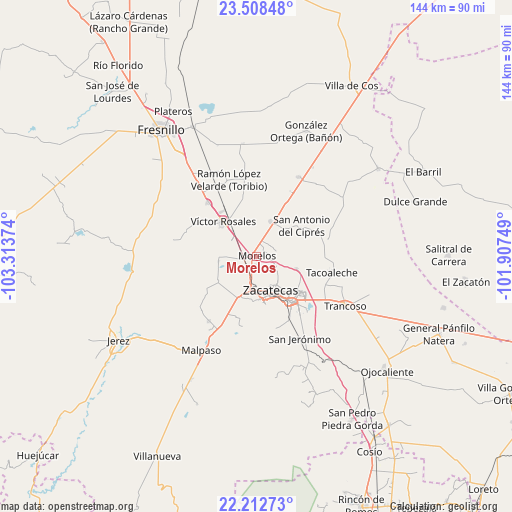
Morelos GPS coordinates[2]
22° 51' 43.74" North, 102° 36' 38.196" West
| Map corner | latitude | longitude |
|---|---|---|
| Upper-left | 23.50848°, | -103.31374° |
| Center: | 22.86215°, | -102.61061° |
| Lower-right: | 22.21273°, | -101.90749° |
| Map W x H: | 144.1×144.1 km | = 89.5×89.5mi |
| max Lat: | 32.7° ⇑12.3% North |
| Morelos: | 22.86215° |
| min Lat: | ⇓87.7% South 14.53588° |
| min Long | Morelos | max Long |
| -117.105° | -102.61061° | -86.73105° |
| W 15.5%⇐ | ⇒84.5% E |
Elevation
Elevation of Morelos is 2309 m = 7575 ft, and this is 1055.3 m = 3462 ft above average elevation for this country.
| Max E: |
3497 m = 11473 ft | 13% |
| Morelos | 2309 m 7575 ft | |
| Avg. | 1253.7 m = 4113 ft | |
Min E: |
-1 m = -3 ft | 87% |
See also: Mexico elevation on elevation.city.
Geographical zone
Morelos is located in North Torrid zone (between Equator and Tropic of Cancer). Distance of this Northern Tropic circle is 63.9 km =39.7 mi to North.| Distance of | km | miles | from Morelos |
|---|---|---|---|
| North Pole | 7465 | 4638.5 | to North |
| Arctic Circle | 4859.1 | 3019.3 | to North |
| Tropic Cancer | 63.9 | 39.7 | to North |
| Equator | 2542 | 1579.5 | to South |


Nearby cities:
15 places around Morelos: (largest is in red/bold)
• Casa de Cerros
9.5 km =5.9 mi,  74°
74°
• Cieneguillas
12.9 km =8 mi,  204°
204°
• Francisco I. Madero
13.1 km =8.1 mi,  236°
236°
• Guadalupe
15.8 km =9.8 mi,  143°
143°
• Hacienda Nueva
4.2 km =2.6 mi,  176°
176°
• Las Pilas
2.5 km =1.6 mi,  185°
185°
• Picones
12.2 km =7.6 mi, 191°
• Pimienta
8.2 km =5.1 mi, 195°
• Pozos de Gamboa
10.5 km =6.5 mi,  23°
23°
• Pánuco
7.3 km =4.5 mi,  77°
77°
• San Antonio del Cipres
15.2 km =9.4 mi,  56°
56°
• Sauceda de La Borda
11.6 km =7.2 mi,  107°
107°
• Vetagrande
6.4 km =4 mi,  119°
119°
• Víctor Rosales
13.5 km =8.4 mi,  315°
315°
• Zacatecas
10.8 km =6.7 mi,  163°
163°
Sources, notices
• [Note1] Compared only with cities in Mexico existing in our database
• [Src1] Map data: © OpenStreetMap contributors (CC-BY-SA)
• [Src2] Other city data from geonames.org with taken over terms of usage.
• [Src3] Geographical zone / Annual Mean Temperature by Robert A. Rohde @ Wikipedia
