Santiaguillo geodata
Santiaguillo (Zacatecas) is a populated place; located in Mexico in America/Mexico_City (GMT-6) time zone. With population of 1,378 people, there are 6291 cities with bigger population in this country. Compared to other cities in Mexico, 88.3% of cities are located further ↓South; 84.6% of cities are located further →East and 77.5% of cities have lower elevation than Santiaguillo. Note1


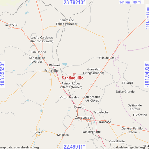
Santiaguillo GPS coordinates[2]
23° 8' 49.848" North, 102° 39' 8.64" West
| Map corner | latitude | longitude |
|---|---|---|
| Upper-left | 23.79213°, | -103.35553° |
| Center: | 23.14718°, | -102.6524° |
| Lower-right: | 22.49911°, | -101.94928° |
| Map W x H: | 143.8×143.8 km | = 89.4×89.4mi |
| max Lat: | 32.7° ⇑11.7% North |
| Santiaguillo: | 23.14718° |
| min Lat: | ⇓88.3% South 14.53588° |
| min Long | Santiaguillo | max Long |
| -117.105° | -102.6524° | -86.73105° |
| W 15.4%⇐ | ⇒84.6% E |
Elevation
Elevation of Santiaguillo is 2079 m = 6821 ft, and this is 825.3 m = 2708 ft above average elevation for this country.
| Max E: |
3497 m = 11473 ft | 22.5% |
| Santiaguillo | 2079 m 6821 ft | |
| Avg. | 1253.7 m = 4113 ft | |
Min E: |
-1 m = -3 ft | 77.5% |
See also: Mexico elevation on elevation.city.
Geographical zone
Santiaguillo is located in North Torrid zone (between Equator and Tropic of Cancer). Distance of this Northern Tropic circle is 32.2 km =20 mi to North.| Distance of | km | miles | from Santiaguillo |
|---|---|---|---|
| North Pole | 7433.3 | 4618.8 | to North |
| Arctic Circle | 4827.4 | 2999.6 | to North |
| Tropic Cancer | 32.2 | 20 | to North |
| Equator | 2573.7 | 1599.2 | to South |


Nearby cities:
15 places around Santiaguillo: (largest is in red/bold)
• Chichimequillas
12.7 km =7.9 mi,  36°
36°
• Colonia Santa Anita
14.8 km =9.2 mi,  307°
307°
• Estación San José
14.3 km =8.9 mi,  289°
289°
• Fraccionamiento San Felipe
16.3 km =10.1 mi,  282°
282°
• Fresnillo
22.7 km =14.1 mi, 279°
• General Enrique Estrada
19 km =11.8 mi,  208°
208°
• Gonzales Ortega
18.4 km =11.4 mi,  78°
78°
• Hacienda Toribio
7.8 km =4.8 mi,  204°
204°
• Laguna Seca
15.9 km =9.9 mi, 292°
• Laguna Seca
18.6 km =11.6 mi,  120°
120°
• Las Catarinas
7.3 km =4.5 mi,  149°
149°
• Plateros
21.5 km =13.4 mi,  295°
295°
• Rafael Yáñez Sosa (El Mezquite)
20.6 km =12.8 mi,  12°
12°
• San Ramón
22.9 km =14.2 mi,  88°
88°
• Víctor Rosales
22.6 km =14 mi,  193°
193°
Sources, notices
• [Note1] Compared only with cities in Mexico existing in our database
• [Src1] Map data: © OpenStreetMap contributors (CC-BY-SA)
• [Src2] Other city data from geonames.org with taken over terms of usage.
• [Src3] Geographical zone / Annual Mean Temperature by Robert A. Rohde @ Wikipedia
