Cañas geodata
Cañas (Zacatecas) is a populated place; located in Mexico in America/Mexico_City (GMT-6) time zone. With population of 1,393 people, there are 6206 cities with bigger population in this country. Compared to other cities in Mexico, 89.4% of cities are located further ↓South; 86.8% of cities are located further →East and 75.7% of cities have lower elevation than Cañas. Note1


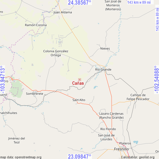
Cañas GPS coordinates[2]
23° 44' 37.176" North, 103° 14' 38.4" West
| Map corner | latitude | longitude |
|---|---|---|
| Upper-left | 24.38567°, | -103.94713° |
| Center: | 23.74366°, | -103.244° |
| Lower-right: | 23.09847°, | -102.54088° |
| Map W x H: | 143.1×143.1 km | = 88.9×88.9mi |
| max Lat: | 32.7° ⇑10.6% North |
| Cañas: | 23.74366° |
| min Lat: | ⇓89.4% South 14.53588° |
| min Long | Cañas | max Long |
| -117.105° | -103.244° | -86.73105° |
| W 13.2%⇐ | ⇒86.8% E |
Elevation
Elevation of Cañas is 2043 m = 6703 ft, and this is 789.3 m = 2590 ft above average elevation for this country.
| Max E: |
3497 m = 11473 ft | 24.3% |
| Cañas | 2043 m 6703 ft | |
| Avg. | 1253.7 m = 4113 ft | |
Min E: |
-1 m = -3 ft | 75.7% |
See also: Mexico elevation on elevation.city.
Geographical zone
Cañas is located in North temperate zone (between Tropic of Cancer and the Arctic Circle). Distance of this Northern Tropic circle is 34.1 km =21.2 mi to South.| Distance of | km | miles | from Cañas |
|---|---|---|---|
| North Pole | 7367 | 4577.6 | to North |
| Arctic Circle | 4761.1 | 2958.4 | to North |
| Tropic Cancer | 34.1 | 21.2 | to South |
| Equator | 2640 | 1640.4 | to South |


Nearby cities:
15 places around Cañas: (largest is in red/bold)
• Barrancas
13.2 km =8.2 mi,  161°
161°
• Cantuna
16.8 km =10.4 mi,  218°
218°
• Ciénega y Mancilla
18.3 km =11.4 mi,  72°
72°
• Colonia Francisco García Salinas
9.8 km =6.1 mi,  40°
40°
• El Cazadero
14.7 km =9.1 mi,  122°
122°
• El Fresno
14 km =8.7 mi,  231°
231°
• El Fuerte
17.5 km =10.9 mi,  45°
45°
• Emiliano Zapata
6 km =3.7 mi, 117°
• José María Morelos y Pavón
16.8 km =10.4 mi, 38°
• La Florida
18.3 km =11.4 mi, 68°
• Las Esperanzas (El Ranchito)
16.5 km =10.3 mi, 44°
• Pastelera
15 km =9.3 mi,  89°
89°
• Sain Alto
18.1 km =11.2 mi,  181°
181°
• Sain Bajo
15.8 km =9.8 mi,  153°
153°
• San Felipe
14.7 km =9.1 mi, 70°
Sources, notices
• [Note1] Compared only with cities in Mexico existing in our database
• [Src1] Map data: © OpenStreetMap contributors (CC-BY-SA)
• [Src2] Other city data from geonames.org with taken over terms of usage.
• [Src3] Geographical zone / Annual Mean Temperature by Robert A. Rohde @ Wikipedia
