El Mirador geodata
El Mirador (San Luis Potosí) is a populated place; located in Mexico in America/Mexico_City (GMT-6) time zone. With population of 614 people, there are 14035 cities with bigger population in this country. Compared to other cities in Mexico, 83.5% of cities are located further ↓South; 72.2% of cities are located further →East and 63.8% of cities have lower elevation than El Mirador. Note1


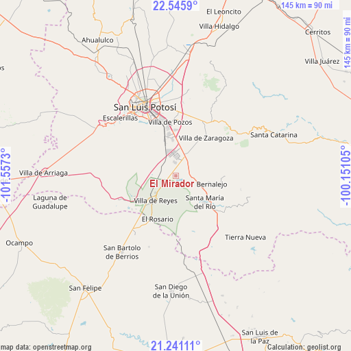
El Mirador GPS coordinates[2]
21° 53' 42" North, 100° 51' 15.012" West
| Map corner | latitude | longitude |
|---|---|---|
| Upper-left | 22.5459°, | -101.5573° |
| Center: | 21.895°, | -100.85417° |
| Lower-right: | 21.24111°, | -100.15105° |
| Map W x H: | 145.1×145.1 km | = 90.2×90.2mi |
| max Lat: | 32.7° ⇑16.5% North |
| El Mirador: | 21.895° |
| min Lat: | ⇓83.5% South 14.53588° |
| min Long | El Mirador | max Long |
| -117.105° | -100.85417° | -86.73105° |
| W 27.8%⇐ | ⇒72.2% E |
Elevation
Elevation of El Mirador is 1797 m = 5896 ft, and this is 543.3 m = 1782 ft above average elevation for this country.
| Max E: |
3497 m = 11473 ft | 36.2% |
| El Mirador | 1797 m 5896 ft | |
| Avg. | 1253.7 m = 4113 ft | |
Min E: |
-1 m = -3 ft | 63.8% |
See also: Mexico elevation on elevation.city.
Geographical zone
El Mirador is located in North Torrid zone (between Equator and Tropic of Cancer). Distance of this Northern Tropic circle is 171.4 km =106.5 mi to North.| Distance of | km | miles | from El Mirador |
|---|---|---|---|
| North Pole | 7572.6 | 4705.4 | to North |
| Arctic Circle | 4966.7 | 3086.2 | to North |
| Tropic Cancer | 171.4 | 106.5 | to North |
| Equator | 2434.5 | 1512.7 | to South |


Nearby cities:
15 places around El Mirador: (largest is in red/bold)
• Cerro Gordo
10.1 km =6.3 mi,  29°
29°
• Ejido Gogorrón (Ex-Hacienda de Gogorrón)
8.5 km =5.3 mi,  224°
224°
• Emiliano Zapata
6.8 km =4.2 mi,  295°
295°
• Enramadas
7.6 km =4.7 mi,  100°
100°
• Guanajuatito (Cerrito de la Cruz)
13.6 km =8.5 mi,  134°
134°
• La Presa (La Presita)
8 km =5 mi, 296°
• Laguna de San Vicente
5.7 km =3.5 mi,  354°
354°
• Machado
8.8 km =5.5 mi,  254°
254°
• Ojo Caliente
11.7 km =7.3 mi,  117°
117°
• Pardo
1.3 km =0.8 mi,  189°
189°
• Rodrigo
10.3 km =6.4 mi,  267°
267°
• San Lorenzo
1.9 km =1.2 mi,  310°
310°
• Socavón (El Carmen)
5.2 km =3.2 mi,  200°
200°
• Texas
12.5 km =7.8 mi,  64°
64°
• Villa de Reyes
13.1 km =8.1 mi, 218°
Sources, notices
• [Note1] Compared only with cities in Mexico existing in our database
• [Src1] Map data: © OpenStreetMap contributors (CC-BY-SA)
• [Src2] Other city data from geonames.org with taken over terms of usage.
• [Src3] Geographical zone / Annual Mean Temperature by Robert A. Rohde @ Wikipedia
