Saltillo geodata
Saltillo (Coahuila) is a seat of a first-order administrative division; located in Mexico in America/Monterrey (GMT-6) time zone. With population of 709,671 people, there are 19 cities with bigger population in this country. Compared to other cities in Mexico, 92.4% of cities are located further ↓South; 73.5% of cities are located further →East and 55.2% of cities have lower elevation than Saltillo. Note1


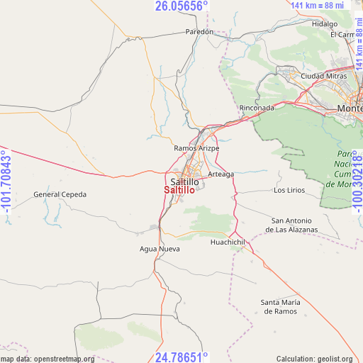
Saltillo GPS coordinates[2]
25° 25' 23.556" North, 101° 0' 19.08" West
| Map corner | latitude | longitude |
|---|---|---|
| Upper-left | 26.05656°, | -101.70843° |
| Center: | 25.42321°, | -101.0053° |
| Lower-right: | 24.78651°, | -100.30218° |
| Map W x H: | 141.2×141.2 km | = 87.7×87.7mi |
| max Lat: | 32.7° ⇑7.6% North |
| Saltillo: | 25.42321° |
| min Lat: | ⇓92.4% South 14.53588° |
| min Long | Saltillo | max Long |
| -117.105° | -101.0053° | -86.73105° |
| W 26.5%⇐ | ⇒73.5% E |
Elevation
Elevation of Saltillo is 1592 m = 5223 ft, and this is 338.3 m = 1110 ft above average elevation for this country.
| Max E: |
3497 m = 11473 ft | 44.8% |
| Saltillo | 1592 m 5223 ft | |
| Avg. | 1253.7 m = 4113 ft | |
Min E: |
-1 m = -3 ft | 55.2% |
See also: Saltillo elevation on elevation.city.
Geographical zone
Saltillo is located in North temperate zone (between Tropic of Cancer and the Arctic Circle). Distance of this Northern Tropic circle is 220.9 km =137.3 mi to South.| Distance of | km | miles | from Saltillo |
|---|---|---|---|
| North Pole | 7180.3 | 4461.6 | to North |
| Arctic Circle | 4574.4 | 2842.4 | to North |
| Tropic Cancer | 220.9 | 137.3 | to South |
| Equator | 2826.8 | 1756.5 | to South |


Nearby cities:
15 places around Saltillo: (largest is in red/bold)
• Agua Nueva
27.3 km =17 mi,  197°
197°
• Arteaga
16.1 km =10 mi,  81°
81°
• Cuatro de Octubre
11.5 km =7.1 mi, 77°
• Derramadero
31.6 km =19.6 mi,  241°
241°
• El Tunal
37.2 km =23.1 mi,  90°
90°
• General Cepeda
47.5 km =29.5 mi,  263°
263°
• Huachichil
29.7 km =18.5 mi,  142°
142°
• Las Torres de Guadalupe
57.3 km =35.6 mi,  42°
42°
• Los Lirios
42 km =26.1 mi, 94°
• Navidad
56.4 km =35 mi,  134°
134°
• Puerto México
40.1 km =24.9 mi, 132°
• Ramos Arizpe
14.2 km =8.8 mi,  24°
24°
• San Antonio de las Alazanas
46.1 km =28.6 mi,  111°
111°
• San Juan de la Vaquería
28.7 km =17.8 mi,  228°
228°
• Valle de San Felipe
57.1 km =35.5 mi, 40°
Sources, notices
• [Note1] Compared only with cities in Mexico existing in our database
• [Src1] Map data: © OpenStreetMap contributors (CC-BY-SA)
• [Src2] Other city data from geonames.org with taken over terms of usage.
• [Src3] Geographical zone / Annual Mean Temperature by Robert A. Rohde @ Wikipedia
