Cuatro de Octubre geodata
Cuatro de Octubre (Coahuila) is a populated place; located in Mexico in America/Monterrey (GMT-6) time zone. With population of 503 people, there are 16722 cities with bigger population in this country. Compared to other cities in Mexico, 92.5% of cities are located further ↓South; 72.6% of cities are located further →East and 54.9% of cities have lower elevation than Cuatro de Octubre. Note1


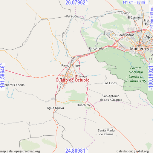
Cuatro de Octubre GPS coordinates[2]
25° 26' 47.004" North, 100° 53' 35.988" West
| Map corner | latitude | longitude |
|---|---|---|
| Upper-left | 26.07962°, | -101.59646° |
| Center: | 25.44639°, | -100.89333° |
| Lower-right: | 24.80981°, | -100.19021° |
| Map W x H: | 141.2×141.2 km | = 87.7×87.7mi |
| max Lat: | 32.7° ⇑7.5% North |
| Cuatro de Octubre: | 25.44639° |
| min Lat: | ⇓92.5% South 14.53588° |
| min Long | Cuatro de Octub | max Long |
| -117.105° | -100.89333° | -86.73105° |
| W 27.4%⇐ | ⇒72.6% E |
Elevation
Elevation of Cuatro de Octubre is 1586 m = 5203 ft, and this is 332.3 m = 1090 ft above average elevation for this country.
| Max E: |
3497 m = 11473 ft | 45.1% |
| Cuatro de Octubre | 1586 m 5203 ft | |
| Avg. | 1253.7 m = 4113 ft | |
Min E: |
-1 m = -3 ft | 54.9% |
See also: Mexico elevation on elevation.city.
Geographical zone
Cuatro de Octubre is located in North temperate zone (between Tropic of Cancer and the Arctic Circle). Distance of this Northern Tropic circle is 223.5 km =138.9 mi to South.| Distance of | km | miles | from Cuatro de Octubre |
|---|---|---|---|
| North Pole | 7177.7 | 4460 | to North |
| Arctic Circle | 4571.8 | 2840.8 | to North |
| Tropic Cancer | 223.5 | 138.9 | to South |
| Equator | 2829.4 | 1758.1 | to South |


Nearby cities:
15 places around Cuatro de Octubre: (largest is in red/bold)
• Agua Nueva
34.7 km =21.6 mi,  214°
214°
• Arteaga
4.7 km =2.9 mi,  91°
91°
• Derramadero
42.8 km =26.6 mi,  246°
246°
• El Tunal
26.1 km =16.2 mi,  96°
96°
• García
50.2 km =31.2 mi,  35°
35°
• Huachichil
27 km =16.8 mi,  165°
165°
• Las Torres de Guadalupe
48.3 km =30 mi,  34°
34°
• Los Lirios
31.2 km =19.4 mi, 100°
• Puerto México
34.8 km =21.6 mi,  148°
148°
• Ramos Arizpe
11.7 km =7.3 mi,  332°
332°
• Saltillo
11.5 km =7.1 mi,  257°
257°
• San Antonio de las Alazanas
37.1 km =23.1 mi,  121°
121°
• San Juan de la Vaquería
39.3 km =24.4 mi,  236°
236°
• Santa Catarina
50.4 km =31.3 mi,  59°
59°
• Valle de San Felipe
48.3 km =30 mi, 32°
Sources, notices
• [Note1] Compared only with cities in Mexico existing in our database
• [Src1] Map data: © OpenStreetMap contributors (CC-BY-SA)
• [Src2] Other city data from geonames.org with taken over terms of usage.
• [Src3] Geographical zone / Annual Mean Temperature by Robert A. Rohde @ Wikipedia
