Independencia y Libertad geodata
Independencia y Libertad (Durango) is a populated place; located in Mexico in America/Monterrey (GMT-6) time zone. With population of 890 people, there are 9797 cities with bigger population in this country. Compared to other cities in Mexico, 90.1% of cities are located further ↓South; 90.7% of cities are located further →East and 65.9% of cities have lower elevation than Independencia y Libertad. Note1
Current local time in Independencia y Libertad:
05:24 AM, WednesdayDifference from your time zone: hours


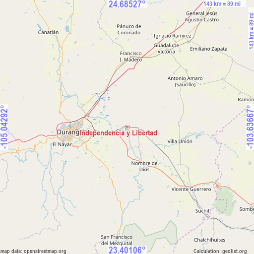
Independencia y Libertad GPS coordinates[2]
24° 2' 41.172" North, 104° 20' 23.244" West
| Map corner | latitude | longitude |
|---|---|---|
| Upper-left | 24.68527°, | -105.04292° |
| Center: | 24.04477°, | -104.33979° |
| Lower-right: | 23.40106°, | -103.63667° |
| Map W x H: | 142.8×142.8 km | = 88.7×88.7mi |
| max Lat: | 32.7° ⇑9.9% North |
| Independencia y Libertad: | 24.04477° |
| min Lat: | ⇓90.1% South 14.53588° |
| min Long | Independencia y | max Long |
| -117.105° | -104.33979° | -86.73105° |
| W 9.3%⇐ | ⇒90.7% E |
Elevation
Elevation of Independencia y Libertad is 1849 m = 6066 ft, and this is 595.3 m = 1953 ft above average elevation for this country.
| Max E: |
3497 m = 11473 ft | 34.1% |
| Independencia y Libertad | 1849 m 6066 ft | |
| Avg. | 1253.7 m = 4113 ft | |
Min E: |
-1 m = -3 ft | 65.9% |
See also: Mexico elevation on elevation.city.
Geographical zone
Independencia y Libertad is located in North temperate zone (between Tropic of Cancer and the Arctic Circle). Distance of this Northern Tropic circle is 67.6 km =42 mi to South.| Distance of | km | miles | from Independencia y Libertad |
|---|---|---|---|
| North Pole | 7333.5 | 4556.8 | to North |
| Arctic Circle | 4727.6 | 2937.6 | to North |
| Tropic Cancer | 67.6 | 42 | to South |
| Equator | 2673.5 | 1661.2 | to South |


Nearby cities:
15 places around Independencia y Libertad: (largest is in red/bold)
• Cinco de Febrero
17.1 km =10.6 mi,  281°
281°
• Contreras
22 km =13.7 mi,  268°
268°
• Damián Carmona
24.1 km =15 mi,  118°
118°
• El Arenal
9.8 km =6.1 mi, 283°
• Héroe de Nacozari
5.2 km =3.2 mi,  237°
237°
• Ignacio López Rayón
20.8 km =12.9 mi,  230°
230°
• José Refugio Salcido
20.2 km =12.6 mi, 243°
• La Constancia
16.2 km =10.1 mi,  152°
152°
• Los Ángeles
24 km =14.9 mi, 118°
• Navacoyán
21.3 km =13.2 mi, 271°
• Nombre de Dios
23.7 km =14.7 mi,  156°
156°
• Parras de la Fuente
20.2 km =12.6 mi,  254°
254°
• Primero de Mayo
1.9 km =1.2 mi,  210°
210°
• Tuitán
9.1 km =5.7 mi,  100°
100°
• Villa Montemorelos
15.5 km =9.6 mi, 247°
Sources, notices
• [Note1] Compared only with cities in Mexico existing in our database
• [Src1] Map data: © OpenStreetMap contributors (CC-BY-SA)
• [Src2] Other city data from geonames.org with taken over terms of usage.
• [Src3] Geographical zone / Annual Mean Temperature by Robert A. Rohde @ Wikipedia
