Villa Union geodata
Villa Union (Coahuila) is a populated place; located in Mexico in America/Monterrey (GMT-6) time zone. With population of 5,147 people, there are 1804 cities with bigger population in this country. Compared to other cities in Mexico, 97.5% of cities are located further ↓South; 71.2% of cities are located further →East and 70.7% of cities have higher elevation than Villa Union. Note1


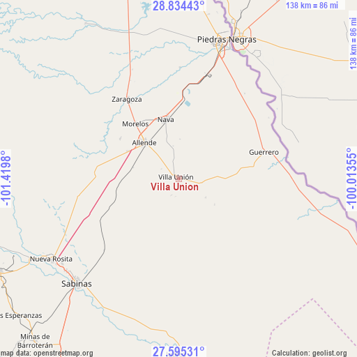
Villa Union GPS coordinates[2]
28° 13' 0.012" North, 100° 43' 0.012" West
| Map corner | latitude | longitude |
|---|---|---|
| Upper-left | 28.83443°, | -101.4198° |
| Center: | 28.21667°, | -100.71667° |
| Lower-right: | 27.59531°, | -100.01355° |
| Map W x H: | 137.8×137.8 km | = 85.6×85.6mi |
| max Lat: | 32.7° ⇑2.5% North |
| Villa Union: | 28.21667° |
| min Lat: | ⇓97.5% South 14.53588° |
| min Long | Villa Union | max Long |
| -117.105° | -100.71667° | -86.73105° |
| W 28.8%⇐ | ⇒71.2% E |
Elevation
Elevation of Villa Union is 381 m = 1250 ft, and this is 872.7 m = 2863 ft below average elevation for this country.
| Max E: |
3497 m = 11473 ft | 70.7% |
| Avg. | 1253.7 m = 4113 ft | |
| Villa Union | 381 m = 1250 ft | |
Min E: |
-1 m = -3 ft | 29.3% |
See also: Mexico elevation on elevation.city.
Geographical zone
Villa Union is located in North temperate zone (between Tropic of Cancer and the Arctic Circle). Distance of this Northern Tropic circle is 531.5 km =330.3 mi to South.| Distance of | km | miles | from Villa Union |
|---|---|---|---|
| North Pole | 6869.7 | 4268.6 | to North |
| Arctic Circle | 4263.8 | 2649.4 | to North |
| Tropic Cancer | 531.5 | 330.3 | to South |
| Equator | 3137.4 | 1949.5 | to South |


Nearby cities:
15 places around Villa Union: (largest is in red/bold)
• Allende
19.1 km =11.9 mi,  316°
316°
• Cloete
55.8 km =34.7 mi,  233°
233°
• Colonia Venustiano Carranza
49.5 km =30.8 mi,  18°
18°
• Fraccionamiento Villa Real
54.6 km =33.9 mi,  13°
13°
• Guerrero
34.5 km =21.4 mi,  72°
72°
• Los Álamos
27.3 km =17 mi,  304°
304°
• Morelos
27 km =16.8 mi, 321°
• Nava
23.2 km =14.4 mi,  348°
348°
• Nueva Rosita
58 km =36 mi,  238°
238°
• Paso del Tío Pío
34.4 km =21.4 mi,  327°
327°
• Piedras Negras
57 km =35.4 mi, 19°
• Río Bravo
22.3 km =13.9 mi, 298°
• Sabinas
56.2 km =34.9 mi,  224°
224°
• Villa Unión
1.1 km =0.7 mi, 303°
• Zaragoza
36.7 km =22.8 mi, 326°
Sources, notices
• [Note1] Compared only with cities in Mexico existing in our database
• [Src1] Map data: © OpenStreetMap contributors (CC-BY-SA)
• [Src2] Other city data from geonames.org with taken over terms of usage.
• [Src3] Geographical zone / Annual Mean Temperature by Robert A. Rohde @ Wikipedia
