Villa Juárez geodata
Villa Juárez (Sonora) is a seat of a second-order administrative division; located in Mexico in America/Hermosillo (GMT-7) time zone. With population of 13,770 people, there are 706 cities with bigger population in this country. Compared to other cities in Mexico, 96.5% of cities are located further ↓South; 98% of cities are located further →East and 92.5% of cities have higher elevation than Villa Juárez. Note1


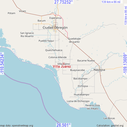
Villa Juárez GPS coordinates[2]
27° 7' 42.636" North, 109° 50' 21.156" West
| Map corner | latitude | longitude |
|---|---|---|
| Upper-left | 27.75252°, | -110.54234° |
| Center: | 27.12851°, | -109.83921° |
| Lower-right: | 26.501°, | -109.13609° |
| Map W x H: | 139.2×139.2 km | = 86.5×86.5mi |
| max Lat: | 32.7° ⇑3.5% North |
| Villa Juárez: | 27.12851° |
| min Lat: | ⇓96.5% South 14.53588° |
| min Long | Villa Juárez | max Long |
| -117.105° | -109.83921° | -86.73105° |
| W 2%⇐ | ⇒98% E |
Elevation
Elevation of Villa Juárez is 18 m = 59 ft, and this is 1235.7 m = 4054 ft below average elevation for this country.
| Max E: |
3497 m = 11473 ft | 92.5% |
| Avg. | 1253.7 m = 4113 ft | |
| Villa Juárez | 18 m = 59 ft | |
Min E: |
-1 m = -3 ft | 7.5% |
See also: Mexico elevation on elevation.city.
Geographical zone
Villa Juárez is located in North temperate zone (between Tropic of Cancer and the Arctic Circle). Distance of this Northern Tropic circle is 410.5 km =255.1 mi to South.| Distance of | km | miles | from Villa Juárez |
|---|---|---|---|
| North Pole | 6990.7 | 4343.8 | to North |
| Arctic Circle | 4384.8 | 2724.6 | to North |
| Tropic Cancer | 410.5 | 255.1 | to South |
| Equator | 3016.4 | 1874.3 | to South |


Nearby cities:
15 places around Villa Juárez: (largest is in red/bold)
• Agua Blanca
10.5 km =6.5 mi,  98°
98°
• Allende
9.8 km =6.1 mi,  316°
316°
• Altos de Jecopaco
7.1 km =4.4 mi,  310°
310°
• Buaysiacobe
16.6 km =10.3 mi,  113°
113°
• El Paredoncito
10.6 km =6.6 mi,  223°
223°
• El Rodeo
23.2 km =14.4 mi,  122°
122°
• Etchohuaquila
22.6 km =14 mi,  21°
21°
• Jecopaco
10.4 km =6.5 mi,  41°
41°
• Jitonhueca
24.3 km =15.1 mi, 107°
• Mocorua
21.7 km =13.5 mi,  150°
150°
• Morelos Uno
22.8 km =14.2 mi, 316°
• Paredón Colorado
10.8 km =6.7 mi,  239°
239°
• Quetchehueca
18.6 km =11.6 mi, 324°
• San Pedro Río Mayo
23.7 km =14.7 mi, 120°
• Santa María del Buáraje
19.5 km =12.1 mi,  10°
10°
Sources, notices
• [Note1] Compared only with cities in Mexico existing in our database
• [Src1] Map data: © OpenStreetMap contributors (CC-BY-SA)
• [Src2] Other city data from geonames.org with taken over terms of usage.
• [Src3] Geographical zone / Annual Mean Temperature by Robert A. Rohde @ Wikipedia
