Quetchehueca geodata
Quetchehueca (Sonora) is a populated place; located in Mexico in America/Hermosillo (GMT-7) time zone. With population of 3,001 people, there are 2995 cities with bigger population in this country. Compared to other cities in Mexico, 96.6% of cities are located further ↓South; 98.1% of cities are located further →East and 89.7% of cities have higher elevation than Quetchehueca. Note1


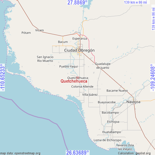
Quetchehueca GPS coordinates[2]
27° 15' 49.14" North, 109° 56' 57.12" West
| Map corner | latitude | longitude |
|---|---|---|
| Upper-left | 27.8869°, | -110.65233° |
| Center: | 27.26365°, | -109.9492° |
| Lower-right: | 26.63689°, | -109.24608° |
| Map W x H: | 139×139 km | = 86.4×86.4mi |
| max Lat: | 32.7° ⇑3.4% North |
| Quetchehueca: | 27.26365° |
| min Lat: | ⇓96.6% South 14.53588° |
| min Long | Quetchehueca | max Long |
| -117.105° | -109.9492° | -86.73105° |
| W 1.9%⇐ | ⇒98.1% E |
Elevation
Elevation of Quetchehueca is 25 m = 82 ft, and this is 1228.7 m = 4031 ft below average elevation for this country.
| Max E: |
3497 m = 11473 ft | 89.7% |
| Avg. | 1253.7 m = 4113 ft | |
| Quetchehueca | 25 m = 82 ft | |
Min E: |
-1 m = -3 ft | 10.3% |
See also: Mexico elevation on elevation.city.
Geographical zone
Quetchehueca is located in North temperate zone (between Tropic of Cancer and the Arctic Circle). Distance of this Northern Tropic circle is 425.5 km =264.4 mi to South.| Distance of | km | miles | from Quetchehueca |
|---|---|---|---|
| North Pole | 6975.6 | 4334.4 | to North |
| Arctic Circle | 4369.7 | 2715.2 | to North |
| Tropic Cancer | 425.5 | 264.4 | to South |
| Equator | 3031.4 | 1883.6 | to South |


Nearby cities:
15 places around Quetchehueca: (largest is in red/bold)
• 31 de Octubre
9.4 km =5.8 mi,  292°
292°
• Allende
9 km =5.6 mi,  152°
152°
• Altos de Jecopaco
11.7 km =7.3 mi, 152°
• Antonio Rosales
13.6 km =8.5 mi,  44°
44°
• Cuauhtémoc (Campo Cinco)
20 km =12.4 mi,  340°
340°
• El Tobarito
13.1 km =8.1 mi,  24°
24°
• Etchohuaquila
20 km =12.4 mi,  72°
72°
• Francisco Villa
18.2 km =11.3 mi,  49°
49°
• Jecopaco
19.2 km =11.9 mi,  112°
112°
• Marte R. Gómez (Tobarito)
13.2 km =8.2 mi,  28°
28°
• Morelos Uno
4.9 km =3 mi, 288°
• Progreso (Campo 47)
16.6 km =10.3 mi,  300°
300°
• Pueblo Yaqui
13.2 km =8.2 mi,  320°
320°
• Santa María del Buáraje
15.1 km =9.4 mi, 73°
• Villa Juárez
18.6 km =11.6 mi,  144°
144°
Sources, notices
• [Note1] Compared only with cities in Mexico existing in our database
• [Src1] Map data: © OpenStreetMap contributors (CC-BY-SA)
• [Src2] Other city data from geonames.org with taken over terms of usage.
• [Src3] Geographical zone / Annual Mean Temperature by Robert A. Rohde @ Wikipedia
