Las Juntas (La Floreña) geodata
Las Juntas (La Floreña) (Colima) is a populated place; located in Mexico in America/Mexico_City (GMT-6) time zone. With population of 884 people, there are 9870 cities with bigger population in this country. Compared to other cities in Mexico, 63.8% of cities are located further ↑North; 90.5% of cities are located further →East and 88% of cities have higher elevation than Las Juntas (La Floreña). Note1
Current local time in Las Juntas (La Floreña):
12:30 PM, MondayDifference from your time zone: hours


Las Juntas (La Floreña) GPS coordinates[2]
19° 3' 19.008" North, 104° 13' 27.012" West
| Map corner | latitude | longitude |
|---|---|---|
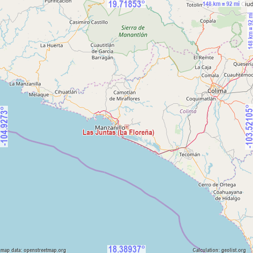
| Upper-left | 19.71853°, | -104.9273° |
| Center: | 19.05528°, | -104.22417° |
| Lower-right: | 18.38937°, | -103.52105° |
| Map W x H: | 147.8×147.8 km | = 91.8×91.8mi |
| max Lat: | 32.7° ⇑63.8% North |
| Las Juntas (La Floreña): | 19.05528° |
| min Lat: | ⇓36.2% South 14.53588° |
| min Long | Las Juntas (La | max Long |
| -117.105° | -104.22417° | -86.73105° |
| W 9.5%⇐ | ⇒90.5% E |
Elevation
Elevation of Las Juntas (La Floreña) is 30 m = 98 ft, and this is 1223.7 m = 4015 ft below average elevation for this country.
| Max E: |
3497 m = 11473 ft | 88% |
| Avg. | 1253.7 m = 4113 ft | |
| Las Juntas (La Floreña) | 30 m = 98 ft | |
Min E: |
-1 m = -3 ft | 12% |
See also: Mexico elevation on elevation.city.
Geographical zone
Las Juntas (La Floreña) is located in North Torrid zone (between Equator and Tropic of Cancer). Distance of this Northern Tropic circle is 487.2 km =302.7 mi to North.| Distance of | km | miles | from Las Juntas (La Floreña) |
|---|---|---|---|
| North Pole | 7888.3 | 4901.6 | to North |
| Arctic Circle | 5282.4 | 3282.3 | to North |
| Tropic Cancer | 487.2 | 302.7 | to North |
| Equator | 2118.7 | 1316.5 | to South |


Nearby cities:
15 places around Las Juntas (La Floreña): (largest is in red/bold)
• Camotlán de Miraflores
18.4 km =11.4 mi,  356°
356°
• Chandiablo
20 km =12.4 mi,  322°
322°
• Cuyutlán
22.3 km =13.9 mi,  132°
132°
• El Colomo
3.7 km =2.3 mi,  280°
280°
• El Garcero
0.7 km =0.4 mi, 275°
• El Naranjo
22 km =13.7 mi,  292°
292°
• Francisco Villa
7.1 km =4.4 mi,  327°
327°
• Jalipa
8.8 km =5.5 mi, 328°
• Los Reyes (Zorrillos)
18.8 km =11.7 mi,  115°
115°
• Manzanillo
14.2 km =8.8 mi,  298°
298°
• Nuevo Cuyutlán
11.9 km =7.4 mi,  109°
109°
• San Buenaventura
8.1 km =5 mi, 123°
• Santa Rita
14.6 km =9.1 mi, 109°
• Tapeixtles
6.4 km =4 mi, 283°
• Venustiano Carranza
12.9 km =8 mi, 112°
Sources, notices
• [Note1] Compared only with cities in Mexico existing in our database
• [Src1] Map data: © OpenStreetMap contributors (CC-BY-SA)
• [Src2] Other city data from geonames.org with taken over terms of usage.
• [Src3] Geographical zone / Annual Mean Temperature by Robert A. Rohde @ Wikipedia
