Jalipa geodata
Jalipa (Colima) is a populated place; located in Mexico in America/Mexico_City (GMT-6) time zone. With population of 2,186 people, there are 4022 cities with bigger population in this country. Compared to other cities in Mexico, 62.7% of cities are located further ↑North; 90.5% of cities are located further →East and 81.1% of cities have higher elevation than Jalipa. Note1


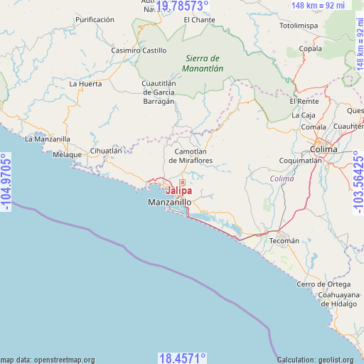
Jalipa GPS coordinates[2]
19° 7' 21.9" North, 104° 16' 2.532" West
| Map corner | latitude | longitude |
|---|---|---|
| Upper-left | 19.78573°, | -104.9705° |
| Center: | 19.12275°, | -104.26737° |
| Lower-right: | 18.4571°, | -103.56425° |
| Map W x H: | 147.7×147.7 km | = 91.8×91.8mi |
| max Lat: | 32.7° ⇑62.7% North |
| Jalipa: | 19.12275° |
| min Lat: | ⇓37.3% South 14.53588° |
| min Long | Jalipa | max Long |
| -117.105° | -104.26737° | -86.73105° |
| W 9.5%⇐ | ⇒90.5% E |
Elevation
Elevation of Jalipa is 81 m = 266 ft, and this is 1172.7 m = 3847 ft below average elevation for this country.
| Max E: |
3497 m = 11473 ft | 81.1% |
| Avg. | 1253.7 m = 4113 ft | |
| Jalipa | 81 m = 266 ft | |
Min E: |
-1 m = -3 ft | 18.9% |
See also: Mexico elevation on elevation.city.
Geographical zone
Jalipa is located in North Torrid zone (between Equator and Tropic of Cancer). Distance of this Northern Tropic circle is 479.7 km =298.1 mi to North.| Distance of | km | miles | from Jalipa |
|---|---|---|---|
| North Pole | 7880.8 | 4896.9 | to North |
| Arctic Circle | 5274.9 | 3277.7 | to North |
| Tropic Cancer | 479.7 | 298.1 | to North |
| Equator | 2126.3 | 1321.2 | to South |


Nearby cities:
15 places around Jalipa: (largest is in red/bold)
• Camotlán de Miraflores
11.4 km =7.1 mi,  17°
17°
• Cedros
18.2 km =11.3 mi,  9°
9°
• Chandiablo
11.3 km =7 mi,  318°
318°
• El Colomo
6.9 km =4.3 mi,  172°
172°
• El Garcero
8.4 km =5.2 mi,  152°
152°
• El Naranjo
15.9 km =9.9 mi,  272°
272°
• Francisco Villa
1.7 km =1.1 mi, 154°
• La Central
18.1 km =11.2 mi,  277°
277°
• Las Juntas (La Floreña)
8.8 km =5.5 mi, 148°
• Manzanillo
7.9 km =4.9 mi, 265°
• Nuevo Cuyutlán
19.5 km =12.1 mi,  126°
126°
• San Buenaventura
16.5 km =10.3 mi,  136°
136°
• Santa Rita
22 km =13.7 mi,  123°
123°
• Tapeixtles
6.2 km =3.9 mi,  195°
195°
• Venustiano Carranza
20.6 km =12.8 mi, 126°
Sources, notices
• [Note1] Compared only with cities in Mexico existing in our database
• [Src1] Map data: © OpenStreetMap contributors (CC-BY-SA)
• [Src2] Other city data from geonames.org with taken over terms of usage.
• [Src3] Geographical zone / Annual Mean Temperature by Robert A. Rohde @ Wikipedia
