Porullo geodata
Porullo (Guanajuato) is a populated place; located in Mexico in America/Mexico_City (GMT-6) time zone. With population of 806 people, there are 10834 cities with bigger population in this country. Compared to other cities in Mexico, 60.7% of cities are located further ↓South; 74.2% of cities are located further →East and 65.5% of cities have lower elevation than Porullo. Note1


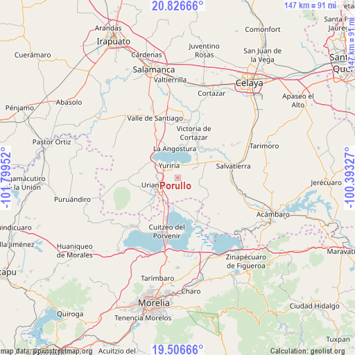
Porullo GPS coordinates[2]
20° 10' 5.016" North, 101° 5' 47.004" West
| Map corner | latitude | longitude |
|---|---|---|
| Upper-left | 20.82666°, | -101.79952° |
| Center: | 20.16806°, | -101.09639° |
| Lower-right: | 19.50666°, | -100.39327° |
| Map W x H: | 146.8×146.8 km | = 91.2×91.2mi |
| max Lat: | 32.7° ⇑39.3% North |
| Porullo: | 20.16806° |
| min Lat: | ⇓60.7% South 14.53588° |
| min Long | Porullo | max Long |
| -117.105° | -101.09639° | -86.73105° |
| W 25.8%⇐ | ⇒74.2% E |
Elevation
Elevation of Porullo is 1842 m = 6043 ft, and this is 588.3 m = 1930 ft above average elevation for this country.
| Max E: |
3497 m = 11473 ft | 34.5% |
| Porullo | 1842 m 6043 ft | |
| Avg. | 1253.7 m = 4113 ft | |
Min E: |
-1 m = -3 ft | 65.5% |
See also: Mexico elevation on elevation.city.
Geographical zone
Porullo is located in North Torrid zone (between Equator and Tropic of Cancer). Distance of this Northern Tropic circle is 363.4 km =225.8 mi to North.| Distance of | km | miles | from Porullo |
|---|---|---|---|
| North Pole | 7764.6 | 4824.7 | to North |
| Arctic Circle | 5158.7 | 3205.5 | to North |
| Tropic Cancer | 363.4 | 225.8 | to North |
| Equator | 2242.5 | 1393.4 | to South |


Nearby cities:
15 places around Porullo: (largest is in red/bold)
• Cervacio Mendoza
8.7 km =5.4 mi,  59°
59°
• Colonia Juárez
6 km =3.7 mi,  243°
243°
• Cupareo
10.6 km =6.6 mi,  50°
50°
• El Charco
4.3 km =2.7 mi,  233°
233°
• El Derramadero
10.2 km =6.3 mi,  199°
199°
• El Salteador
3.8 km =2.4 mi,  148°
148°
• El Timbinal
9.7 km =6 mi, 148°
• Las Misiones
7.7 km =4.8 mi,  264°
264°
• Parangarico
7.7 km =4.8 mi,  290°
290°
• San José Cuaracurio
9.7 km =6 mi,  221°
221°
• San Miguel el Alto (San Miguelito)
9.8 km =6.1 mi,  297°
297°
• Santiago Maravatío
10.6 km =6.6 mi,  87°
87°
• Tinaja de Pastores
4.9 km =3 mi, 46°
• Uriangato
9.5 km =5.9 mi,  251°
251°
• Yuriria
6 km =3.7 mi,  321°
321°
Sources, notices
• [Note1] Compared only with cities in Mexico existing in our database
• [Src1] Map data: © OpenStreetMap contributors (CC-BY-SA)
• [Src2] Other city data from geonames.org with taken over terms of usage.
• [Src3] Geographical zone / Annual Mean Temperature by Robert A. Rohde @ Wikipedia
