Parangarico geodata
Parangarico (Guanajuato) is a populated place; located in Mexico in America/Mexico_City (GMT-6) time zone. With population of 2,316 people, there are 3810 cities with bigger population in this country. Compared to other cities in Mexico, 61.2% of cities are located further ↓South; 74.7% of cities are located further →East and 62.8% of cities have lower elevation than Parangarico. Note1


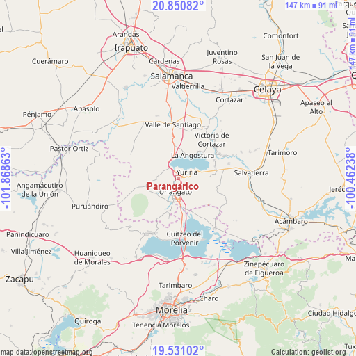
Parangarico GPS coordinates[2]
20° 11' 32.352" North, 101° 9' 55.8" West
| Map corner | latitude | longitude |
|---|---|---|
| Upper-left | 20.85082°, | -101.86863° |
| Center: | 20.19232°, | -101.1655° |
| Lower-right: | 19.53102°, | -100.46238° |
| Map W x H: | 146.7×146.7 km | = 91.2×91.2mi |
| max Lat: | 32.7° ⇑38.8% North |
| Parangarico: | 20.19232° |
| min Lat: | ⇓61.2% South 14.53588° |
| min Long | Parangarico | max Long |
| -117.105° | -101.1655° | -86.73105° |
| W 25.3%⇐ | ⇒74.7% E |
Elevation
Elevation of Parangarico is 1775 m = 5823 ft, and this is 521.3 m = 1710 ft above average elevation for this country.
| Max E: |
3497 m = 11473 ft | 37.2% |
| Parangarico | 1775 m 5823 ft | |
| Avg. | 1253.7 m = 4113 ft | |
Min E: |
-1 m = -3 ft | 62.8% |
See also: Mexico elevation on elevation.city.
Geographical zone
Parangarico is located in North Torrid zone (between Equator and Tropic of Cancer). Distance of this Northern Tropic circle is 360.7 km =224.1 mi to North.| Distance of | km | miles | from Parangarico |
|---|---|---|---|
| North Pole | 7761.9 | 4823 | to North |
| Arctic Circle | 5156 | 3203.8 | to North |
| Tropic Cancer | 360.7 | 224.1 | to North |
| Equator | 2245.2 | 1395.1 | to South |


Nearby cities:
15 places around Parangarico: (largest is in red/bold)
• Cahuageo
9.9 km =6.2 mi,  21°
21°
• Colonia Juárez
5.6 km =3.5 mi,  160°
160°
• El Charco
6.4 km =4 mi,  144°
144°
• Gervasio Mendoza
10.9 km =6.8 mi,  11°
11°
• Las Misiones
3.5 km =2.2 mi,  187°
187°
• Monte de los Juárez
9 km =5.6 mi,  263°
263°
• Moroleón
7.9 km =4.9 mi,  200°
200°
• Ochomitas
5.5 km =3.4 mi,  309°
309°
• Porullo
7.7 km =4.8 mi,  110°
110°
• San Andrés Enguaro
7.4 km =4.6 mi,  272°
272°
• San José Cuaracurio
9.9 km =6.2 mi,  175°
175°
• San Miguel el Alto (San Miguelito)
2.3 km =1.4 mi,  319°
319°
• Tinaja de Pastores
10.8 km =6.7 mi,  86°
86°
• Uriangato
6 km =3.7 mi, 197°
• Yuriria
4 km =2.5 mi,  59°
59°
Sources, notices
• [Note1] Compared only with cities in Mexico existing in our database
• [Src1] Map data: © OpenStreetMap contributors (CC-BY-SA)
• [Src2] Other city data from geonames.org with taken over terms of usage.
• [Src3] Geographical zone / Annual Mean Temperature by Robert A. Rohde @ Wikipedia
