La Angostura geodata
La Angostura (Guanajuato) is a populated place; located in Mexico in America/Mexico_City (GMT-6) time zone. With population of 1,410 people, there are 6134 cities with bigger population in this country. Compared to other cities in Mexico, 63.1% of cities are located further ↓South; 74.3% of cities are located further →East and 61.2% of cities have lower elevation than La Angostura. Note1


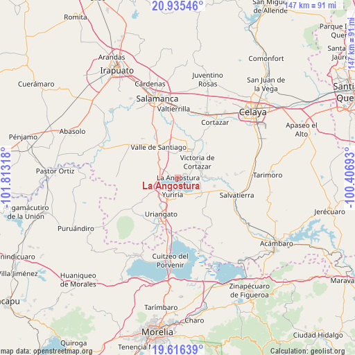
La Angostura GPS coordinates[2]
20° 16' 38.388" North, 101° 6' 36.18" West
| Map corner | latitude | longitude |
|---|---|---|
| Upper-left | 20.93546°, | -101.81318° |
| Center: | 20.27733°, | -101.11005° |
| Lower-right: | 19.61639°, | -100.40693° |
| Map W x H: | 146.7×146.7 km | = 91.2×91.2mi |
| max Lat: | 32.7° ⇑36.9% North |
| La Angostura: | 20.27733° |
| min Lat: | ⇓63.1% South 14.53588° |
| min Long | La Angostura | max Long |
| -117.105° | -101.11005° | -86.73105° |
| W 25.7%⇐ | ⇒74.3% E |
Elevation
Elevation of La Angostura is 1747 m = 5732 ft, and this is 493.3 m = 1618 ft above average elevation for this country.
| Max E: |
3497 m = 11473 ft | 38.8% |
| La Angostura | 1747 m 5732 ft | |
| Avg. | 1253.7 m = 4113 ft | |
Min E: |
-1 m = -3 ft | 61.2% |
See also: Mexico elevation on elevation.city.
Geographical zone
La Angostura is located in North Torrid zone (between Equator and Tropic of Cancer). Distance of this Northern Tropic circle is 351.3 km =218.3 mi to North.| Distance of | km | miles | from La Angostura |
|---|---|---|---|
| North Pole | 7752.4 | 4817.1 | to North |
| Arctic Circle | 5146.5 | 3197.9 | to North |
| Tropic Cancer | 351.3 | 218.3 | to North |
| Equator | 2254.6 | 1400.9 | to South |


Nearby cities:
15 places around La Angostura: (largest is in red/bold)
• Bella Vista de Santa María
9.5 km =5.9 mi,  353°
353°
• Cahuageo
2.1 km =1.3 mi,  263°
263°
• El Perico
9.2 km =5.7 mi,  342°
342°
• Gervasio Mendoza
3.8 km =2.4 mi,  288°
288°
• Loma de Zempoala
3.5 km =2.2 mi,  62°
62°
• Magdalena de Araceo
8 km =5 mi,  296°
296°
• Pozo de Aróstegui (Las Correas)
9.3 km =5.8 mi, 338°
• Puerta del Monte
9 km =5.6 mi,  103°
103°
• San Jerónimo de Araceo
9.2 km =5.7 mi,  305°
305°
• San José de Ojo Zarco
10.5 km =6.5 mi, 60°
• Santiago Capitiro
10.1 km =6.3 mi,  72°
72°
• Tinaja de Pastores
10.1 km =6.3 mi,  150°
150°
• Victoria de Cortazar
10.4 km =6.5 mi,  52°
52°
• Yuriria
7.7 km =4.8 mi,  197°
197°
• Zempoala
5.5 km =3.4 mi,  36°
36°
Sources, notices
• [Note1] Compared only with cities in Mexico existing in our database
• [Src1] Map data: © OpenStreetMap contributors (CC-BY-SA)
• [Src2] Other city data from geonames.org with taken over terms of usage.
• [Src3] Geographical zone / Annual Mean Temperature by Robert A. Rohde @ Wikipedia
