Tepache geodata
Tepache (Sonora) is a seat of a second-order administrative division; located in Mexico in America/Hermosillo (GMT-7) time zone. With population of 1,305 people, there are 6645 cities with bigger population in this country. Compared to other cities in Mexico, 98.3% of cities are located further ↓South; 97.5% of cities are located further →East and 66.7% of cities have higher elevation than Tepache. Note1


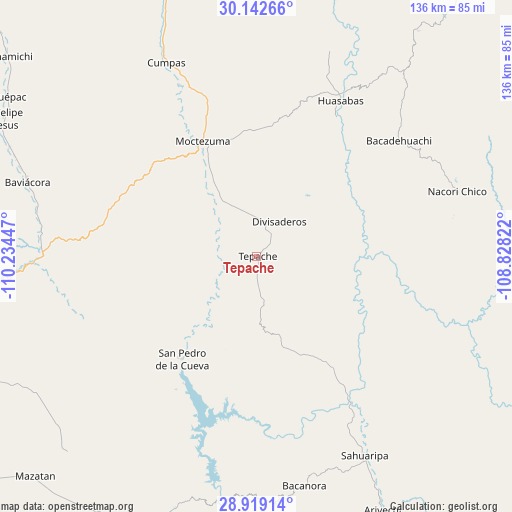
Tepache GPS coordinates[2]
29° 31' 57.9" North, 109° 31' 52.824" West
| Map corner | latitude | longitude |
|---|---|---|
| Upper-left | 30.14266°, | -110.23447° |
| Center: | 29.53275°, | -109.53134° |
| Lower-right: | 28.91914°, | -108.82822° |
| Map W x H: | 136×136 km | = 84.5×84.5mi |
| max Lat: | 32.7° ⇑1.7% North |
| Tepache: | 29.53275° |
| min Lat: | ⇓98.3% South 14.53588° |
| min Long | Tepache | max Long |
| -117.105° | -109.53134° | -86.73105° |
| W 2.5%⇐ | ⇒97.5% E |
Elevation
Elevation of Tepache is 601 m = 1972 ft, and this is 652.7 m = 2141 ft below average elevation for this country.
| Max E: |
3497 m = 11473 ft | 66.7% |
| Avg. | 1253.7 m = 4113 ft | |
| Tepache | 601 m = 1972 ft | |
Min E: |
-1 m = -3 ft | 33.3% |
See also: Mexico elevation on elevation.city.
Geographical zone
Tepache is located in North temperate zone (between Tropic of Cancer and the Arctic Circle). Distance of this Northern Tropic circle is 677.8 km =421.2 mi to South.| Distance of | km | miles | from Tepache |
|---|---|---|---|
| North Pole | 6723.3 | 4177.7 | to North |
| Arctic Circle | 4117.4 | 2558.4 | to North |
| Tropic Cancer | 677.8 | 421.2 | to South |
| Equator | 3283.7 | 2040.4 | to South |


Nearby cities:
15 places around Tepache: (largest is in red/bold)
• Bacadéhuachi
48.7 km =30.3 mi,  50°
50°
• Bacanora
62.6 km =38.9 mi,  168°
168°
• Baviácora
64.3 km =40 mi,  288°
288°
• Cumpas
56.8 km =35.3 mi,  334°
334°
• Divisaderos
10.9 km =6.8 mi,  33°
33°
• Granados
42.4 km =26.3 mi, 30°
• Huásabas
47.3 km =29.4 mi, 28°
• Jécori
49.1 km =30.5 mi,  336°
336°
• Moctezuma
33.6 km =20.9 mi, 334°
• Nácori Chico
56 km =34.8 mi,  72°
72°
• Ojo de Agua
60.9 km =37.8 mi, 335°
• Pueblo de Álamos
69.3 km =43.1 mi,  238°
238°
• Sahuaripa
60.5 km =37.6 mi,  151°
151°
• San Pedro de la Cueva
33.8 km =21 mi,  216°
216°
• Villa Pesqueira
62.6 km =38.9 mi, 222°
Sources, notices
• [Note1] Compared only with cities in Mexico existing in our database
• [Src1] Map data: © OpenStreetMap contributors (CC-BY-SA)
• [Src2] Other city data from geonames.org with taken over terms of usage.
• [Src3] Geographical zone / Annual Mean Temperature by Robert A. Rohde @ Wikipedia
