Cumpas geodata
Cumpas (Sonora) is a seat of a second-order administrative division; located in Mexico in America/Hermosillo (GMT-7) time zone. With population of 3,003 people, there are 2992 cities with bigger population in this country. Compared to other cities in Mexico, 98.5% of cities are located further ↓South; 97.9% of cities are located further →East and 64.1% of cities have higher elevation than Cumpas. Note1


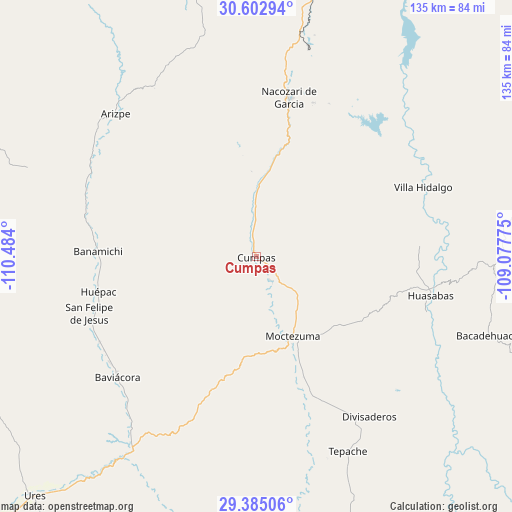
Cumpas GPS coordinates[2]
29° 59' 45.132" North, 109° 46' 51.132" West
| Map corner | latitude | longitude |
|---|---|---|
| Upper-left | 30.60294°, | -110.484° |
| Center: | 29.99587°, | -109.78087° |
| Lower-right: | 29.38506°, | -109.07775° |
| Map W x H: | 135.4×135.4 km | = 84.1×84.1mi |
| max Lat: | 32.7° ⇑1.5% North |
| Cumpas: | 29.99587° |
| min Lat: | ⇓98.5% South 14.53588° |
| min Long | Cumpas | max Long |
| -117.105° | -109.78087° | -86.73105° |
| W 2.1%⇐ | ⇒97.9% E |
Elevation
Elevation of Cumpas is 748 m = 2454 ft, and this is 505.7 m = 1659 ft below average elevation for this country.
| Max E: |
3497 m = 11473 ft | 64.1% |
| Avg. | 1253.7 m = 4113 ft | |
| Cumpas | 748 m = 2454 ft | |
Min E: |
-1 m = -3 ft | 35.9% |
See also: Mexico elevation on elevation.city.
Geographical zone
Cumpas is located in North temperate zone (between Tropic of Cancer and the Arctic Circle). Distance of this Northern Tropic circle is 729.3 km =453.2 mi to South.| Distance of | km | miles | from Cumpas |
|---|---|---|---|
| North Pole | 6671.8 | 4145.7 | to North |
| Arctic Circle | 4065.9 | 2526.4 | to North |
| Tropic Cancer | 729.3 | 453.2 | to South |
| Equator | 3335.2 | 2072.4 | to South |


Nearby cities:
15 places around Cumpas: (largest is in red/bold)
• Aconchi
46.8 km =29.1 mi,  246°
246°
• Banámichi
41.9 km =26 mi,  271°
271°
• Baviácora
48.4 km =30.1 mi,  229°
229°
• Granados
47.7 km =29.6 mi,  108°
108°
• Huásabas
47.3 km =29.4 mi,  101°
101°
• Huépac
42.7 km =26.5 mi,  257°
257°
• Jécori
7.9 km =4.9 mi,  146°
146°
• La Estancia
47 km =29.2 mi,  241°
241°
• Los Hoyos
14.3 km =8.9 mi,  359°
359°
• Moctezuma
23.2 km =14.4 mi,  155°
155°
• Nacozari Viejo
46.7 km =29 mi,  15°
15°
• Nacozari de García
43.1 km =26.8 mi,  11°
11°
• Ojo de Agua
4.2 km =2.6 mi,  349°
349°
• San Felipe de Jesús
46.5 km =28.9 mi, 251°
• Villa Hidalgo
47.9 km =29.8 mi,  67°
67°
Sources, notices
• [Note1] Compared only with cities in Mexico existing in our database
• [Src1] Map data: © OpenStreetMap contributors (CC-BY-SA)
• [Src2] Other city data from geonames.org with taken over terms of usage.
• [Src3] Geographical zone / Annual Mean Temperature by Robert A. Rohde @ Wikipedia
