Villa Pesqueira geodata
Villa Pesqueira (Sonora) is a seat of a second-order administrative division; located in Mexico in America/Hermosillo (GMT-7) time zone. With population of 629 people, there are 13762 cities with bigger population in this country. Compared to other cities in Mexico, 98.1% of cities are located further ↓South; 98.1% of cities are located further →East and 64.2% of cities have higher elevation than Villa Pesqueira. Note1


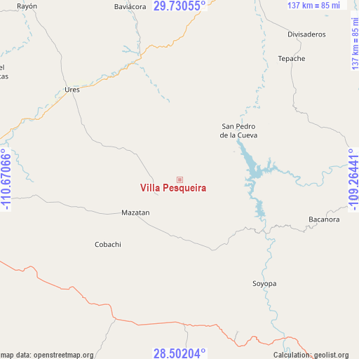
Villa Pesqueira GPS coordinates[2]
29° 7' 5.268" North, 109° 58' 3.108" West
| Map corner | latitude | longitude |
|---|---|---|
| Upper-left | 29.73055°, | -110.67066° |
| Center: | 29.11813°, | -109.96753° |
| Lower-right: | 28.50204°, | -109.26441° |
| Map W x H: | 136.6×136.6 km | = 84.9×84.9mi |
| max Lat: | 32.7° ⇑1.9% North |
| Villa Pesqueira: | 29.11813° |
| min Lat: | ⇓98.1% South 14.53588° |
| min Long | Villa Pesqueira | max Long |
| -117.105° | -109.96753° | -86.73105° |
| W 1.9%⇐ | ⇒98.1% E |
Elevation
Elevation of Villa Pesqueira is 740 m = 2428 ft, and this is 513.7 m = 1685 ft below average elevation for this country.
| Max E: |
3497 m = 11473 ft | 64.2% |
| Avg. | 1253.7 m = 4113 ft | |
| Villa Pesqueira | 740 m = 2428 ft | |
Min E: |
-1 m = -3 ft | 35.8% |
See also: Mexico elevation on elevation.city.
Geographical zone
Villa Pesqueira is located in North temperate zone (between Tropic of Cancer and the Arctic Circle). Distance of this Northern Tropic circle is 631.7 km =392.5 mi to South.| Distance of | km | miles | from Villa Pesqueira |
|---|---|---|---|
| North Pole | 6769.4 | 4206.3 | to North |
| Arctic Circle | 4163.5 | 2587.1 | to North |
| Tropic Cancer | 631.7 | 392.5 | to South |
| Equator | 3237.6 | 2011.8 | to South |


Nearby cities:
15 places around Villa Pesqueira: (largest is in red/bold)
• Bacanora
57.2 km =35.5 mi,  105°
105°
• Baviácora
68.9 km =42.8 mi,  344°
344°
• Divisaderos
73.4 km =45.6 mi,  41°
41°
• Guadalupe
55.3 km =34.4 mi,  302°
302°
• La Colorada
69.1 km =42.9 mi,  239°
239°
• Mazatán
20.8 km =12.9 mi,  232°
232°
• Molino de Camou
77.3 km =48 mi,  277°
277°
• Pueblo de Álamos
19.5 km =12.1 mi, 300°
• Sahuaripa
71.6 km =44.5 mi,  95°
95°
• San Javier
62.2 km =38.6 mi,  159°
159°
• San Pedro de la Cueva
29.2 km =18.1 mi,  50°
50°
• Soyopa
51 km =31.7 mi,  140°
140°
• Tecoripa
55 km =34.2 mi,  178°
178°
• Tepache
62.6 km =38.9 mi, 42°
• Ures
53.3 km =33.1 mi,  310°
310°
Sources, notices
• [Note1] Compared only with cities in Mexico existing in our database
• [Src1] Map data: © OpenStreetMap contributors (CC-BY-SA)
• [Src2] Other city data from geonames.org with taken over terms of usage.
• [Src3] Geographical zone / Annual Mean Temperature by Robert A. Rohde @ Wikipedia
