Bacadéhuachi geodata
Bacadéhuachi (Sonora) is a seat of a second-order administrative division; located in Mexico in America/Hermosillo (GMT-7) time zone. With population of 1,251 people, there are 6933 cities with bigger population in this country. Compared to other cities in Mexico, 98.4% of cities are located further ↓South; 97.2% of cities are located further →East and 64.7% of cities have higher elevation than Bacadéhuachi. Note1


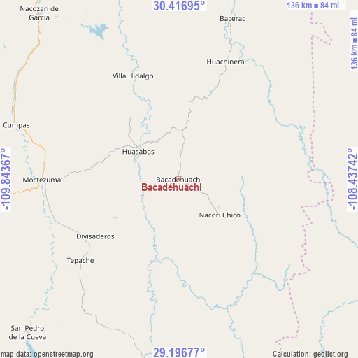
Bacadéhuachi GPS coordinates[2]
29° 48' 31.392" North, 109° 8' 25.944" West
| Map corner | latitude | longitude |
|---|---|---|
| Upper-left | 30.41695°, | -109.84367° |
| Center: | 29.80872°, | -109.14054° |
| Lower-right: | 29.19677°, | -108.43742° |
| Map W x H: | 135.7×135.7 km | = 84.3×84.3mi |
| max Lat: | 32.7° ⇑1.6% North |
| Bacadéhuachi: | 29.80872° |
| min Lat: | ⇓98.4% South 14.53588° |
| min Long | Bacadéhuachi | max Long |
| -117.105° | -109.14054° | -86.73105° |
| W 2.8%⇐ | ⇒97.2% E |
Elevation
Elevation of Bacadéhuachi is 702 m = 2303 ft, and this is 551.7 m = 1810 ft below average elevation for this country.
| Max E: |
3497 m = 11473 ft | 64.7% |
| Avg. | 1253.7 m = 4113 ft | |
| Bacadéhuachi | 702 m = 2303 ft | |
Min E: |
-1 m = -3 ft | 35.3% |
See also: Mexico elevation on elevation.city.
Geographical zone
Bacadéhuachi is located in North temperate zone (between Tropic of Cancer and the Arctic Circle). Distance of this Northern Tropic circle is 708.5 km =440.2 mi to South.| Distance of | km | miles | from Bacadéhuachi |
|---|---|---|---|
| North Pole | 6692.6 | 4158.6 | to North |
| Arctic Circle | 4086.8 | 2539.4 | to North |
| Tropic Cancer | 708.5 | 440.2 | to South |
| Equator | 3314.4 | 2059.5 | to South |


Nearby cities:
15 places around Bacadéhuachi: (largest is in red/bold)
• Bacerac
64.1 km =39.8 mi,  18°
18°
• Cumpas
65.1 km =40.5 mi,  288°
288°
• Divisaderos
38.4 km =23.9 mi,  235°
235°
• Granados
17.4 km =10.8 mi, 289°
• Huachinera
48 km =29.8 mi, 21°
• Huásabas
19 km =11.8 mi,  305°
305°
• Jécori
59.2 km =36.8 mi,  283°
283°
• La Norteña
68.9 km =42.8 mi,  105°
105°
• Los Hoyos
71.1 km =44.2 mi,  299°
299°
• Mesa Tres Ríos
41.5 km =25.8 mi,  85°
85°
• Moctezuma
52 km =32.3 mi,  269°
269°
• Nácori Chico
20.5 km =12.7 mi,  131°
131°
• Ojo de Agua
67.3 km =41.8 mi, 291°
• Tepache
48.7 km =30.3 mi,  230°
230°
• Villa Hidalgo
43 km =26.7 mi,  336°
336°
Sources, notices
• [Note1] Compared only with cities in Mexico existing in our database
• [Src1] Map data: © OpenStreetMap contributors (CC-BY-SA)
• [Src2] Other city data from geonames.org with taken over terms of usage.
• [Src3] Geographical zone / Annual Mean Temperature by Robert A. Rohde @ Wikipedia
