Tacuro (Santa María Tacuro) geodata
Tacuro (Santa María Tacuro) (Michoacán) is a populated place; located in Mexico in America/Mexico_City (GMT-6) time zone. With population of 2,050 people, there are 4252 cities with bigger population in this country. Compared to other cities in Mexico, 54.2% of cities are located further ↓South; 81.2% of cities are located further →East and 68.5% of cities have lower elevation than Tacuro (Santa María Tacuro). Note1
Current local time in Tacuro (Santa María Tacuro):
12:46 AM, WednesdayDifference from your time zone: hours


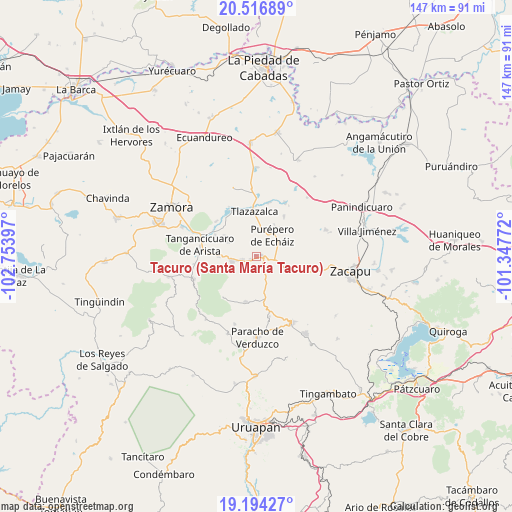
Tacuro (Santa María Tacuro) GPS coordinates[2]
19° 51' 25.056" North, 102° 3' 3.024" West
| Map corner | latitude | longitude |
|---|---|---|
| Upper-left | 20.51689°, | -102.75397° |
| Center: | 19.85696°, | -102.05084° |
| Lower-right: | 19.19427°, | -101.34772° |
| Map W x H: | 147.1×147.1 km | = 91.4×91.4mi |
| max Lat: | 32.7° ⇑45.8% North |
| Tacuro (Santa María Tacuro): | 19.85696° |
| min Lat: | ⇓54.2% South 14.53588° |
| min Long | Tacuro (Santa M | max Long |
| -117.105° | -102.05084° | -86.73105° |
| W 18.8%⇐ | ⇒81.2% E |
Elevation
Elevation of Tacuro (Santa María Tacuro) is 1898 m = 6227 ft, and this is 644.3 m = 2114 ft above average elevation for this country.
| Max E: |
3497 m = 11473 ft | 31.5% |
| Tacuro (Santa María Tacuro) | 1898 m 6227 ft | |
| Avg. | 1253.7 m = 4113 ft | |
Min E: |
-1 m = -3 ft | 68.5% |
See also: Mexico elevation on elevation.city.
Geographical zone
Tacuro (Santa María Tacuro) is located in North Torrid zone (between Equator and Tropic of Cancer). Distance of this Northern Tropic circle is 398 km =247.3 mi to North.| Distance of | km | miles | from Tacuro (Santa María Tacuro) |
|---|---|---|---|
| North Pole | 7799.2 | 4846.2 | to North |
| Arctic Circle | 5193.3 | 3227 | to North |
| Tropic Cancer | 398 | 247.3 | to North |
| Equator | 2207.9 | 1371.9 | to South |


Nearby cities:
15 places around Tacuro (Santa María Tacuro): (largest is in red/bold)
• Acachuén
4.5 km =2.8 mi,  256°
256°
• Carapán
1.5 km =0.9 mi,  77°
77°
• Chilchota
7 km =4.3 mi, 260°
• Etúcuaro
9.1 km =5.7 mi,  295°
295°
• Huancito
2 km =1.2 mi,  243°
243°
• Ichán
0.4 km =0.2 mi,  289°
289°
• Los Llanos
8.5 km =5.3 mi,  111°
111°
• Los Nogales
11 km =6.8 mi,  270°
270°
• Purépero de Echáiz
7.6 km =4.7 mi,  38°
38°
• Santo Tomás
3.9 km =2.4 mi,  250°
250°
• Tanaquillo
5.1 km =3.2 mi, 256°
• Tlazazalca
12.7 km =7.9 mi,  356°
356°
• Urén
5.8 km =3.6 mi, 257°
• Valle de Guadalupe
10.7 km =6.6 mi, 303°
• Zopoco
3.1 km =1.9 mi,  233°
233°
Sources, notices
• [Note1] Compared only with cities in Mexico existing in our database
• [Src1] Map data: © OpenStreetMap contributors (CC-BY-SA)
• [Src2] Other city data from geonames.org with taken over terms of usage.
• [Src3] Geographical zone / Annual Mean Temperature by Robert A. Rohde @ Wikipedia
