Los Llanos geodata
Los Llanos (Michoacán) is a populated place; located in Mexico in America/Mexico_City (GMT-6) time zone. With population of 588 people, there are 14598 cities with bigger population in this country. Compared to other cities in Mexico, 53.6% of cities are located further ↓South; 80.8% of cities are located further →East and 81.4% of cities have lower elevation than Los Llanos. Note1


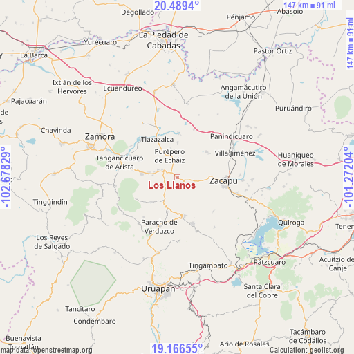
Los Llanos GPS coordinates[2]
19° 49' 45.66" North, 101° 58' 30.576" West
| Map corner | latitude | longitude |
|---|---|---|
| Upper-left | 20.4894°, | -102.67829° |
| Center: | 19.82935°, | -101.97516° |
| Lower-right: | 19.16655°, | -101.27204° |
| Map W x H: | 147.1×147.1 km | = 91.4×91.4mi |
| max Lat: | 32.7° ⇑46.4% North |
| Los Llanos: | 19.82935° |
| min Lat: | ⇓53.6% South 14.53588° |
| min Long | Los Llanos | max Long |
| -117.105° | -101.97516° | -86.73105° |
| W 19.2%⇐ | ⇒80.8% E |
Elevation
Elevation of Los Llanos is 2173 m = 7129 ft, and this is 919.3 m = 3016 ft above average elevation for this country.
| Max E: |
3497 m = 11473 ft | 18.6% |
| Los Llanos | 2173 m 7129 ft | |
| Avg. | 1253.7 m = 4113 ft | |
Min E: |
-1 m = -3 ft | 81.4% |
See also: Mexico elevation on elevation.city.
Geographical zone
Los Llanos is located in North Torrid zone (between Equator and Tropic of Cancer). Distance of this Northern Tropic circle is 401.1 km =249.2 mi to North.| Distance of | km | miles | from Los Llanos |
|---|---|---|---|
| North Pole | 7802.2 | 4848.1 | to North |
| Arctic Circle | 5196.4 | 3228.9 | to North |
| Tropic Cancer | 401.1 | 249.2 | to North |
| Equator | 2204.8 | 1370 | to South |


Nearby cities:
15 places around Los Llanos: (largest is in red/bold)
• Acachuén
12.5 km =7.8 mi,  279°
279°
• Carapán
7.3 km =4.5 mi,  298°
298°
• Casimiro Leco (El Cerecito)
7 km =4.3 mi,  175°
175°
• Cherán Atzicuirín (Cheranástico)
15 km =9.3 mi,  196°
196°
• Colonia Eréndira
10.7 km =6.6 mi,  95°
95°
• El Pueblito
4.8 km =3 mi, 101°
• Huancito
9.9 km =6.2 mi, 282°
• Ichán
8.9 km =5.5 mi,  291°
291°
• Las Canoas
10.9 km =6.8 mi, 102°
• Purépero de Echáiz
9.6 km =6 mi,  340°
340°
• Santo Tomás
11.7 km =7.3 mi, 278°
• Tacuro (Santa María Tacuro)
8.5 km =5.3 mi, 291°
• Tanaquillo
13 km =8.1 mi, 278°
• Urén
13.7 km =8.5 mi, 277°
• Zopoco
10.5 km =6.5 mi, 276°
Sources, notices
• [Note1] Compared only with cities in Mexico existing in our database
• [Src1] Map data: © OpenStreetMap contributors (CC-BY-SA)
• [Src2] Other city data from geonames.org with taken over terms of usage.
• [Src3] Geographical zone / Annual Mean Temperature by Robert A. Rohde @ Wikipedia
