Tanaquillo geodata
Tanaquillo (State of Mexico) is a populated place; located in Mexico in America/Mexico_City (GMT-6) time zone. With population of 1,398 people, there are 6191 cities with bigger population in this country. Compared to other cities in Mexico, 54% of cities are located further ↓South; 81.5% of cities are located further →East and 63.5% of cities have lower elevation than Tanaquillo. Note1


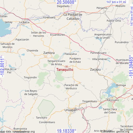
Tanaquillo GPS coordinates[2]
19° 50' 45.996" North, 102° 5' 52.692" West
| Map corner | latitude | longitude |
|---|---|---|
| Upper-left | 20.50608°, | -102.8011° |
| Center: | 19.84611°, | -102.09797° |
| Lower-right: | 19.18338°, | -101.39485° |
| Map W x H: | 147.1×147.1 km | = 91.4×91.4mi |
| max Lat: | 32.7° ⇑46% North |
| Tanaquillo: | 19.84611° |
| min Lat: | ⇓54% South 14.53588° |
| min Long | Tanaquillo | max Long |
| -117.105° | -102.09797° | -86.73105° |
| W 18.5%⇐ | ⇒81.5% E |
Elevation
Elevation of Tanaquillo is 1789 m = 5869 ft, and this is 535.3 m = 1756 ft above average elevation for this country.
| Max E: |
3497 m = 11473 ft | 36.5% |
| Tanaquillo | 1789 m 5869 ft | |
| Avg. | 1253.7 m = 4113 ft | |
Min E: |
-1 m = -3 ft | 63.5% |
See also: Mexico elevation on elevation.city.
Geographical zone
Tanaquillo is located in North Torrid zone (between Equator and Tropic of Cancer). Distance of this Northern Tropic circle is 399.2 km =248.1 mi to North.| Distance of | km | miles | from Tanaquillo |
|---|---|---|---|
| North Pole | 7800.4 | 4846.9 | to North |
| Arctic Circle | 5194.5 | 3227.7 | to North |
| Tropic Cancer | 399.2 | 248.1 | to North |
| Equator | 2206.7 | 1371.2 | to South |


Nearby cities:
15 places around Tanaquillo: (largest is in red/bold)
• Acachuén
0.6 km =0.4 mi,  78°
78°
• Carapán
6.6 km =4.1 mi, 76°
• Chilchota
2 km =1.2 mi,  271°
271°
• Etúcuaro
6.2 km =3.9 mi,  327°
327°
• Gómez Farías
10.5 km =6.5 mi,  324°
324°
• Huancito
3.2 km =2 mi, 84°
• Huécato
11.6 km =7.2 mi,  204°
204°
• Ichán
4.8 km =3 mi,  73°
73°
• Los Nogales
6.2 km =3.9 mi,  281°
281°
• Purépero de Echáiz
12 km =7.5 mi,  53°
53°
• Santo Tomás
1.3 km =0.8 mi,  94°
94°
• Tacuro (Santa María Tacuro)
5.1 km =3.2 mi, 76°
• Urén
0.8 km =0.5 mi, 266°
• Valle de Guadalupe
8.2 km =5.1 mi, 330°
• Zopoco
2.5 km =1.6 mi,  104°
104°
Sources, notices
• [Note1] Compared only with cities in Mexico existing in our database
• [Src1] Map data: © OpenStreetMap contributors (CC-BY-SA)
• [Src2] Other city data from geonames.org with taken over terms of usage.
• [Src3] Geographical zone / Annual Mean Temperature by Robert A. Rohde @ Wikipedia
