Purépero de Echáiz geodata
Purépero de Echáiz (Michoacán) is a populated place; located in Mexico in America/Mexico_City (GMT-6) time zone. With population of 13,856 people, there are 701 cities with bigger population in this country. Compared to other cities in Mexico, 55.3% of cities are located further ↓South; 81% of cities are located further →East and 74.5% of cities have lower elevation than Purépero de Echáiz. Note1


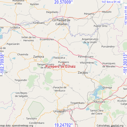
Purépero de Echáiz GPS coordinates[2]
19° 54' 37.404" North, 102° 0' 22.5" West
| Map corner | latitude | longitude |
|---|---|---|
| Upper-left | 20.57009°, | -102.70938° |
| Center: | 19.91039°, | -102.00625° |
| Lower-right: | 19.24792°, | -101.30313° |
| Map W x H: | 147×147 km | = 91.3×91.3mi |
| max Lat: | 32.7° ⇑44.7% North |
| Purépero de Echáiz: | 19.91039° |
| min Lat: | ⇓55.3% South 14.53588° |
| min Long | Purépero de Ec | max Long |
| -117.105° | -102.00625° | -86.73105° |
| W 19%⇐ | ⇒81% E |
Elevation
Elevation of Purépero de Echáiz is 2022 m = 6634 ft, and this is 768.3 m = 2521 ft above average elevation for this country.
| Max E: |
3497 m = 11473 ft | 25.5% |
| Purépero de Echáiz | 2022 m 6634 ft | |
| Avg. | 1253.7 m = 4113 ft | |
Min E: |
-1 m = -3 ft | 74.5% |
See also: Mexico elevation on elevation.city.
Geographical zone
Purépero de Echáiz is located in North Torrid zone (between Equator and Tropic of Cancer). Distance of this Northern Tropic circle is 392.1 km =243.6 mi to North.| Distance of | km | miles | from Purépero de Echáiz |
|---|---|---|---|
| North Pole | 7793.2 | 4842.5 | to North |
| Arctic Circle | 5187.3 | 3223.2 | to North |
| Tropic Cancer | 392.1 | 243.6 | to North |
| Equator | 2213.8 | 1375.6 | to South |


Nearby cities:
15 places around Purépero de Echáiz: (largest is in red/bold)
• Acachuén
11.5 km =7.1 mi,  232°
232°
• Acuitzeramo
10.1 km =6.3 mi,  21°
21°
• Carapán
6.4 km =4 mi,  209°
209°
• El Pueblito
12.8 km =8 mi,  141°
141°
• Etúcuaro
13 km =8.1 mi,  261°
261°
• Huancito
9.4 km =5.8 mi,  223°
223°
• Ichán
7.7 km =4.8 mi, 220°
• La Yerbabuena
9.6 km =6 mi,  353°
353°
• Los Llanos
9.6 km =6 mi,  160°
160°
• Santo Tomás
11 km =6.8 mi, 228°
• Tacuro (Santa María Tacuro)
7.6 km =4.7 mi, 218°
• Tanaquillo
12 km =7.5 mi, 233°
• Tlazazalca
8.7 km =5.4 mi,  320°
320°
• Urén
12.6 km =7.8 mi,  235°
235°
• Zopoco
10.6 km =6.6 mi, 222°
Sources, notices
• [Note1] Compared only with cities in Mexico existing in our database
• [Src1] Map data: © OpenStreetMap contributors (CC-BY-SA)
• [Src2] Other city data from geonames.org with taken over terms of usage.
• [Src3] Geographical zone / Annual Mean Temperature by Robert A. Rohde @ Wikipedia
