Los Santiagos geodata
Los Santiagos (Zacatecas) is a populated place; located in Mexico in America/Mexico_City (GMT-6) time zone. With population of 581 people, there are 14753 cities with bigger population in this country. Compared to other cities in Mexico, 82.2% of cities are located further ↓South; 85.6% of cities are located further →East and 50.9% of cities have higher elevation than Los Santiagos. Note1


Los Santiagos GPS coordinates[2]
21° 39' 18" North, 102° 57' 36" West
| Map corner | latitude | longitude |
|---|---|---|
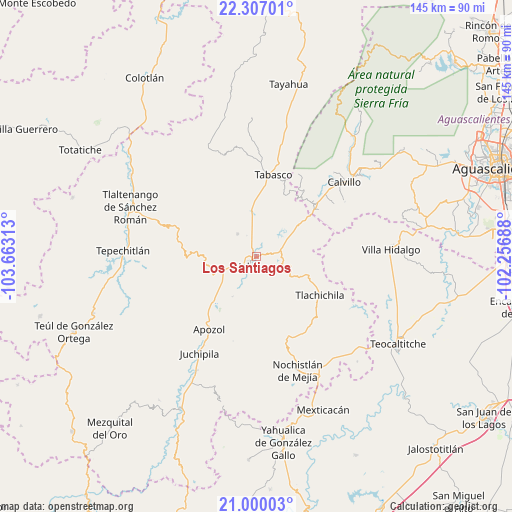
| Upper-left | 22.30701°, | -103.66313° |
| Center: | 21.655°, | -102.96° |
| Lower-right: | 21.00003°, | -102.25688° |
| Map W x H: | 145.3×145.3 km | = 90.3×90.3mi |
| max Lat: | 32.7° ⇑17.8% North |
| Los Santiagos: | 21.655° |
| min Lat: | ⇓82.2% South 14.53588° |
| min Long | Los Santiagos | max Long |
| -117.105° | -102.96° | -86.73105° |
| W 14.4%⇐ | ⇒85.6% E |
Elevation
Elevation of Los Santiagos is 1384 m = 4541 ft, and this is 130.3 m = 427 ft above average elevation for this country.
| Max E: |
3497 m = 11473 ft | 50.9% |
| Los Santiagos | 1384 m 4541 ft | |
| Avg. | 1253.7 m = 4113 ft | |
Min E: |
-1 m = -3 ft | 49.1% |
See also: Mexico elevation on elevation.city.
Geographical zone
Los Santiagos is located in North Torrid zone (between Equator and Tropic of Cancer). Distance of this Northern Tropic circle is 198.1 km =123.1 mi to North.| Distance of | km | miles | from Los Santiagos |
|---|---|---|---|
| North Pole | 7599.3 | 4722 | to North |
| Arctic Circle | 4993.4 | 3102.8 | to North |
| Tropic Cancer | 198.1 | 123.1 | to North |
| Equator | 2407.8 | 1496.1 | to South |


Nearby cities:
15 places around Los Santiagos: (largest is in red/bold)
• Apozol
24.7 km =15.3 mi,  213°
213°
• Colonia Unión Obrera
3.3 km =2.1 mi,  270°
270°
• El Rosario
22.4 km =13.9 mi,  103°
103°
• El Salitre
26.8 km =16.7 mi,  46°
46°
• Guadalupe Victoria
8.4 km =5.2 mi,  320°
320°
• Huanusco
13.3 km =8.3 mi,  354°
354°
• Huiscolco
26.6 km =16.5 mi,  3°
3°
• Jalpa
3 km =1.9 mi,  220°
220°
• Jaltiche de Arriba
22.2 km =13.8 mi, 52°
• La Rinconada
22.4 km =13.9 mi, 48°
• Los Llamas
21.6 km =13.4 mi, 218°
• Ojo de Agua
23.9 km =14.9 mi, 49°
• Presa de los Serna
21 km =13 mi,  36°
36°
• Tabasco
23.7 km =14.7 mi,  12°
12°
• Tlachichila
21 km =13 mi,  121°
121°
Sources, notices
• [Note1] Compared only with cities in Mexico existing in our database
• [Src1] Map data: © OpenStreetMap contributors (CC-BY-SA)
• [Src2] Other city data from geonames.org with taken over terms of usage.
• [Src3] Geographical zone / Annual Mean Temperature by Robert A. Rohde @ Wikipedia
