Jalpa geodata
Jalpa (Zacatecas) is a seat of a second-order administrative division; located in Mexico in America/Mexico_City (GMT-6) time zone. With population of 14,199 people, there are 682 cities with bigger population in this country. Compared to other cities in Mexico, 82.1% of cities are located further ↓South; 85.7% of cities are located further →East and 50.9% of cities have higher elevation than Jalpa. Note1


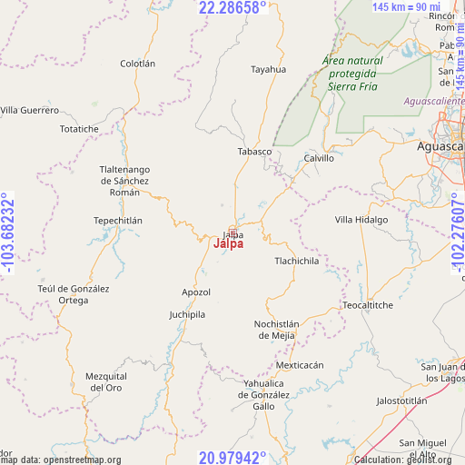
Jalpa GPS coordinates[2]
21° 38' 4.128" North, 102° 58' 45.084" West
| Map corner | latitude | longitude |
|---|---|---|
| Upper-left | 22.28658°, | -103.68232° |
| Center: | 21.63448°, | -102.97919° |
| Lower-right: | 20.97942°, | -102.27607° |
| Map W x H: | 145.3×145.3 km | = 90.3×90.3mi |
| max Lat: | 32.7° ⇑17.9% North |
| Jalpa: | 21.63448° |
| min Lat: | ⇓82.1% South 14.53588° |
| min Long | Jalpa | max Long |
| -117.105° | -102.97919° | -86.73105° |
| W 14.3%⇐ | ⇒85.7% E |
Elevation
Elevation of Jalpa is 1387 m = 4551 ft, and this is 133.3 m = 437 ft above average elevation for this country.
| Max E: |
3497 m = 11473 ft | 50.9% |
| Jalpa | 1387 m 4551 ft | |
| Avg. | 1253.7 m = 4113 ft | |
Min E: |
-1 m = -3 ft | 49.1% |
See also: Mexico elevation on elevation.city.
Geographical zone
Jalpa is located in North Torrid zone (between Equator and Tropic of Cancer). Distance of this Northern Tropic circle is 200.4 km =124.5 mi to North.| Distance of | km | miles | from Jalpa |
|---|---|---|---|
| North Pole | 7601.5 | 4723.4 | to North |
| Arctic Circle | 4995.6 | 3104.1 | to North |
| Tropic Cancer | 200.4 | 124.5 | to North |
| Equator | 2405.5 | 1494.7 | to South |


Nearby cities:
15 places around Jalpa: (largest is in red/bold)
• Apozol
21.7 km =13.5 mi,  212°
212°
• Colonia Unión Obrera
2.6 km =1.6 mi,  329°
329°
• El Rosario
24 km =14.9 mi,  97°
97°
• Guadalupe Victoria
9.4 km =5.8 mi,  339°
339°
• Huanusco
15.5 km =9.6 mi,  2°
2°
• Jaltiche de Arriba
25.2 km =15.7 mi,  51°
51°
• Juchipila
28.9 km =18 mi, 209°
• La Rinconada
25.4 km =15.8 mi, 47°
• Los Llamas
18.6 km =11.6 mi,  218°
218°
• Los Santiagos
3 km =1.9 mi,  40°
40°
• Ojo de Agua
26.9 km =16.7 mi, 48°
• Presa de los Serna
24 km =14.9 mi, 36°
• San José (San José de los Meléndez)
28.2 km =17.5 mi, 212°
• Tabasco
26.4 km =16.4 mi,  15°
15°
• Tlachichila
21.7 km =13.5 mi,  113°
113°
Sources, notices
• [Note1] Compared only with cities in Mexico existing in our database
• [Src1] Map data: © OpenStreetMap contributors (CC-BY-SA)
• [Src2] Other city data from geonames.org with taken over terms of usage.
• [Src3] Geographical zone / Annual Mean Temperature by Robert A. Rohde @ Wikipedia
